Fayl:Cape Kazantip, Kerch Peninsula, Southern Sea of Azov, Ukraine.JPG

Sınaq göstərişi ölçüsü: 800 × 533 piksel. Digər ölçülər: 320 × 213 piksel | 640 × 426 piksel | 1.024 × 682 piksel | 1.280 × 852 piksel | 2.560 × 1.705 piksel | 6.048 × 4.028 piksel.
Faylın orijinalı (6.048 × 4.028 piksel, fayl həcmi: 3,96 MB, MIME növü: image/jpeg)
| Bu fayl "Vikimedia Commons"dadır və digər layihələrdə istifadə edilə bilər. |
 |
Faylın təsvir səhifəsinə get |
Xülasə
| İzah |
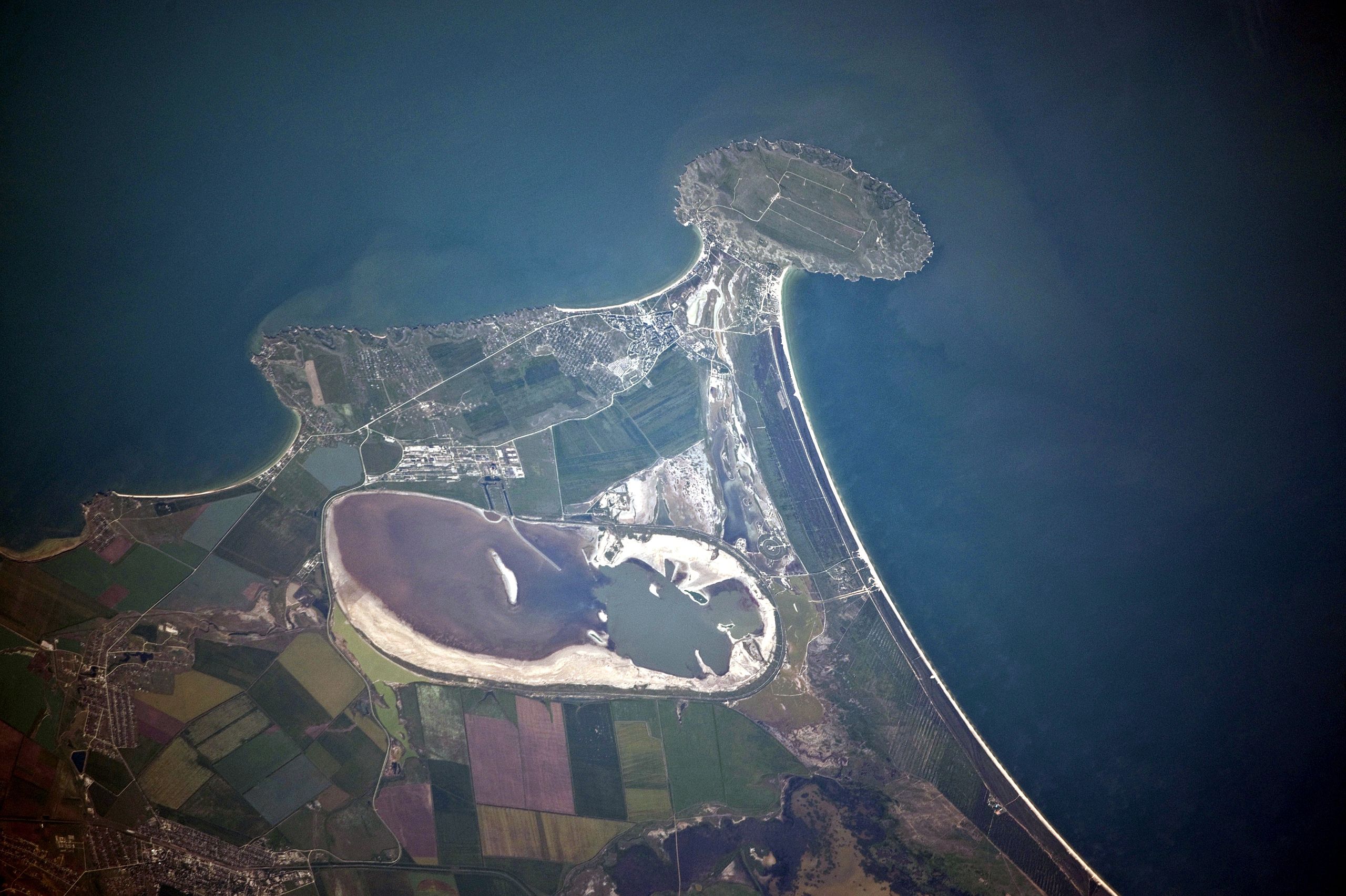
English: Cape Kazantip is a prominent headland on the Kerch Peninsula, which defines the southern shore of the Sea of Azov and the east extension of the Crimean Peninsula. During the Second World War, German and Soviet forces fought on the Kerch Peninsula, with the line of battle impinging on areas shown at the bottom of the image. The distance from the tip of the Cape to the largest local city, Lenine (population ~70,000, image lower left) is only 20 kilometres.
Français : A l'est de la péninsule de Crimée, Cap Kazantip est un promontoire sur la péninsule de Kertch, sur la rive sud de la mer d'Azov. Pendant la Seconde Guerre mondiale, les forces allemandes et soviétiques se sont battus sur la péninsule de Kertch. De la pointe du Cap à plus grande ville locale, Lenine (population ~ 70 000), il y a 20 kilomètres. Une centrale nucléaire en construction a été suspendue en 1989, suite à la chute du bloc soviétique. |
| Tarix | |
| Mənbə | NASA Earth Observatory |
| Müəllif | ISS Expedition 23 crew |
| Camera location | | View this and other nearby images on: OpenStreetMap |
|---|
This image or video was catalogued by Johnson Space Center of the United States National Aeronautics and Space Administration (NASA) under Photo ID: ISS023-E-56842. This tag does not indicate the copyright status of the attached work. A normal copyright tag is still required. See Commons:Licensing. Other languages:
|
This detailed astronaut photograph was taken from the International Space Station (ISS) when it was located 400 kilometres to the north-east, but due to the long (800 mm) lens used, the photo includes detailed field patterns and city blocks. Green and brown fields show intensive agricultural activity in the area, and salt ponds are visible at the west end of the shallow Lake Aktashskoye at image centre.
Lisenziya
| This file is in the public domain in the United States because it was solely created by NASA. NASA copyright policy states that "NASA material is not protected by copyright unless noted". (See Template:PD-USGov, NASA copyright policy page or JPL Image Use Policy.) | ||
 |
Warnings:
|
| Annotations | This image is annotated: View the annotations at Commons |
Faylın tarixçəsi
Faylın əvvəlki versiyasını görmək üçün gün/tarix bölməsindəki tarixlərə klikləyin.
| Tarix/Vaxt | Kiçik şəkil | Ölçülər | İstifadəçi | Şərh | |
|---|---|---|---|---|---|
| indiki | 12:42, 20 iyul 2010 | | 6.048 × 4.028 (3,96 MB) | Originalwana | {{Information |Description={{en|1=Cape Kazantip is a prominent headland on the Kerch Peninsula, which defines the southern shore of the Sea of Azov and the east extension of the Crimean Peninsula. During the [[World W |
Fayl keçidləri
Aşağıdakı səhifə bu faylı istifadə edir:
Faylın qlobal istifadəsi
Bu fayl aşağıdakı vikilərdə istifadə olunur:
- arz.wikipedia.org layihəsində istifadəsi
- be.wikipedia.org layihəsində istifadəsi
- ceb.wikipedia.org layihəsində istifadəsi
- crh.wikipedia.org layihəsində istifadəsi
- de.wikipedia.org layihəsində istifadəsi
- en.wikipedia.org layihəsində istifadəsi
- eo.wikipedia.org layihəsində istifadəsi
- es.wikipedia.org layihəsində istifadəsi
- fa.wikipedia.org layihəsində istifadəsi
- fi.wikipedia.org layihəsində istifadəsi
- fr.wikipedia.org layihəsində istifadəsi
- hr.wikipedia.org layihəsində istifadəsi
- hy.wikipedia.org layihəsində istifadəsi
- ka.wikipedia.org layihəsində istifadəsi
- nn.wikipedia.org layihəsində istifadəsi
- pl.wikipedia.org layihəsində istifadəsi
- ro.wikipedia.org layihəsində istifadəsi
- ru.wikipedia.org layihəsində istifadəsi
- ru.wikivoyage.org layihəsində istifadəsi
- uk.wikipedia.org layihəsində istifadəsi
- www.wikidata.org layihəsində istifadəsi