Fayl:Anatolia1200.png
Daha yüksək versiyası yoxdur.
Anatolia1200.png (642 × 430 piksel, fayl həcmi: 86 KB, MIME növü: image/png)
| Bu fayl "Vikimedia Commons"dadır və digər layihələrdə istifadə edilə bilər. |
 |
Faylın təsvir səhifəsinə get |

|
This historical map image could be re-created using vector graphics as an SVG file. This has several advantages; see Commons:Media for cleanup for more information. If an SVG form of this image is available, please upload it and afterwards replace this template with
{{vector version available|new image name}}.
It is recommended to name the SVG file “Anatolia1200.svg”—then the template Vector version available (or Vva) does not need the new image name parameter. |
Xülasə
| İzah |
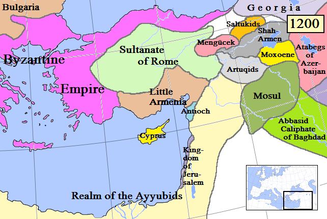
English: Map of Anatolia and some surrounding regions in AD 1200.
(Partially based on Euratlas map of Europe, 1200.) |
| Tarix | |
| Mənbə | Öz işi |
| Müəllif | Gabagool |
| Digər versiyalar |
Derivative works of this file: Kingdom of Cilicia-Anatolia1200-Masry.jpg |
Lisenziya
I, the copyright holder of this work, hereby publish it under the following license:
This file is licensed under the Creative Commons Attribution 3.0 Unported license.
- Azadsınız:
- paylaşmaq – əsəri köçürmək, paylamaq və ötürmək üçün
- remiks etmək – əsəri adaptasiya etmək
- Aşağıdakı şərtlərə riayət etməklə:
- istinad – Müvafiq kredit verməlisiniz, lisenziyaya bir keçid verməlisiniz və dəyişikliklərin olub olmadığını bildirməlisiniz. Bunu hər hansı bir ağlabatan şəkildə edə bilərsiniz, ancaq lisenziyalaşdırıcının sizi və ya istifadənizi təsdiqləməsini təklif edən bir şəkildə deyil.
Faylın tarixçəsi
Faylın əvvəlki versiyasını görmək üçün gün/tarix bölməsindəki tarixlərə klikləyin.
| Tarix/Vaxt | Kiçik şəkil | Ölçülər | İstifadəçi | Şərh | |
|---|---|---|---|---|---|
| indiki | 15:55, 19 aprel 2009 | | 642 × 430 (86 KB) | Gabagool | Added more names to states. Cyprus now yellow to match other maps better. |
| 22:37, 17 aprel 2009 |  | 642 × 430 (84 KB) | Gabagool | Extended Shah-Armen area per [http://en.wikipedia.org/wiki/Sassoun] ("The region was later ruled by the Mamikonian dynasty from around 772 until 1189/1190, when the Mamikonians moved to Cilicia after being dispossessed by Shah-Armen.") New Armenia -> Litt | |
| 23:54, 2 aprel 2009 |  | 642 × 430 (84 KB) | Gabagool | {{Information |Description={{en|1=Map of Anatolia and some surrounding regions in AD 1200. (Partially based on Euratlas map of Europe, 1200.)}} |Source=Own work by uploader |Author=Gabagool |Date=2009-04-03 |Permission= |other_versions= |
Fayl keçidləri
Aşağıdakı 3 səhifə bu faylı istifadə edir:
Faylın qlobal istifadəsi
Bu fayl aşağıdakı vikilərdə istifadə olunur:
- ar.wikipedia.org layihəsində istifadəsi
- ast.wikipedia.org layihəsində istifadəsi
- azb.wikipedia.org layihəsində istifadəsi
- be.wikipedia.org layihəsində istifadəsi
- de.wikipedia.org layihəsində istifadəsi
- el.wikipedia.org layihəsində istifadəsi
- en.wikipedia.org layihəsində istifadəsi
- eo.wikipedia.org layihəsində istifadəsi
- es.wikipedia.org layihəsində istifadəsi
- et.wikipedia.org layihəsində istifadəsi
- fa.wikipedia.org layihəsində istifadəsi
- fr.wikipedia.org layihəsində istifadəsi
- gl.wikipedia.org layihəsində istifadəsi
- hy.wikipedia.org layihəsində istifadəsi
- hyw.wikipedia.org layihəsində istifadəsi
- it.wikipedia.org layihəsində istifadəsi
- ja.wikipedia.org layihəsində istifadəsi
- ka.wikipedia.org layihəsində istifadəsi
- kk.wikipedia.org layihəsində istifadəsi
- ko.wikipedia.org layihəsində istifadəsi
- lt.wikipedia.org layihəsində istifadəsi
- ml.wikipedia.org layihəsində istifadəsi
- nl.wikipedia.org layihəsində istifadəsi
- no.wikipedia.org layihəsində istifadəsi
- pnb.wikipedia.org layihəsində istifadəsi
- pt.wikipedia.org layihəsində istifadəsi
- ro.wikipedia.org layihəsində istifadəsi
- ru.wikipedia.org layihəsində istifadəsi
- sh.wikipedia.org layihəsində istifadəsi
Bu faylın qlobal istifadəsinə baxın.