Fayl:Breakwater break1 new(USGS).jpg

Faylın orijinalı (1.493 × 984 piksel, fayl həcmi: 812 KB, MIME növü: image/jpeg)
| Bu fayl "Vikimedia Commons"dadır və digər layihələrdə istifadə edilə bilər. |
.jpg?uselang=az) |
Faylın təsvir səhifəsinə get |
.jpg)
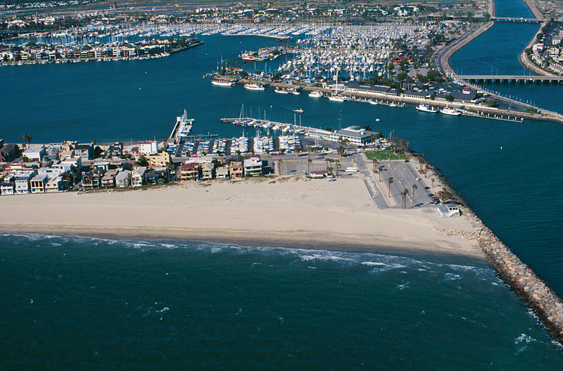
Breakwater.
Breakwaters create safe harbors but can also trap sediment moving along the coast. Long Beach Harbor, April, 1998
From: USGS
A more accurate description: The sand buildup shown is on the southeast end of the Long Beach Peninsula, with the jetty blocking the southward movement of sand being the west side of the entrance to Alamitos Bay. In the background, to the right of the center, is the Alamitos Bay Landing commercial area of the Long Beach Marina. To the far right in the back is the w:San Gabriel River. In the back top left is the sotheast end of w:Naples, a residential island in Alamitos Bay. The ocean shown in the foreground is the very southeast end of the Long Beach Outer Harbor.
This work is in the public domain in the United States because it is a work prepared by an officer or employee of the United States Government as part of that person’s official duties under the terms of Title 17, Chapter 1, Section 105 of the US Code.
Note: This only applies to original works of the Federal Government and not to the work of any individual U.S. state, territory, commonwealth, county, municipality, or any other subdivision. This template also does not apply to postage stamp designs published by the United States Postal Service since 1978. (See § 313.6(C)(1) of Compendium of U.S. Copyright Office Practices). It also does not apply to certain US coins; see The US Mint Terms of Use.
|
 | |
| This file has been identified as being free of known restrictions under copyright law, including all related and neighboring rights. | ||
Faylın tarixçəsi
Faylın əvvəlki versiyasını görmək üçün gün/tarix bölməsindəki tarixlərə klikləyin.
| Tarix/Vaxt | Kiçik şəkil | Ölçülər | İstifadəçi | Şərh | |
|---|---|---|---|---|---|
| indiki | 09:31, 10 iyun 2010 | | 1.493 × 984 (812 KB) | Quibik | cropped away 3 px from right edge and cloned the bottom edge a bit to remove black background |
| 09:28, 10 iyun 2010 |  | 1.496 × 984 (814 KB) | Quibik | removed the timestamp | |
| 18:05, 11 dekabr 2009 |  | 1.496 × 984 (841 KB) | Foobaz | Larger version from http://coastal.er.usgs.gov/cgi-bin/response.pl?site=sc&loc=25 . | |
| 09:02, 21 aprel 2005 |  | 295 × 193 (9 KB) | Feydey | Breakwater. Breakwaters create safe harbors but can also trap sediment moving along the coast. Long Beach Harbor, April, 1998 From: [http://walrus.wr.usgs.gov/cabrillo/playa/breakwater.html USGS] {{PD-USGov}} |
Fayl keçidləri
Aşağıdakı səhifə bu faylı istifadə edir:
Faylın qlobal istifadəsi
Bu fayl aşağıdakı vikilərdə istifadə olunur:
- da.wikipedia.org layihəsində istifadəsi
- el.wikipedia.org layihəsində istifadəsi
- en.wikipedia.org layihəsində istifadəsi
- fi.wikipedia.org layihəsində istifadəsi
- he.wikipedia.org layihəsində istifadəsi
- id.wikipedia.org layihəsində istifadəsi
- kn.wikipedia.org layihəsində istifadəsi
- ml.wikipedia.org layihəsində istifadəsi
- sco.wikipedia.org layihəsində istifadəsi
- simple.wikipedia.org layihəsində istifadəsi
- vi.wikipedia.org layihəsində istifadəsi
.jpg)