Fayl:Chukchi-txu-oclc-6654394-nq-1-2-2nd-ed.jpg
Sınaq göstərişi ölçüsü: 738 × 599 piksel. Digər ölçülər: 296 × 240 piksel | 591 × 480 piksel | 946 × 768 piksel | 1.261 × 1.024 piksel | 2.522 × 2.048 piksel | 4.440 × 3.606 piksel.
Faylın orijinalı (4.440 × 3.606 piksel, fayl həcmi: 3,42 MB, MIME növü: image/jpeg)
| Bu fayl "Vikimedia Commons"dadır və digər layihələrdə istifadə edilə bilər. |
 |
Faylın təsvir səhifəsinə get |
Xülasə
| İzah |
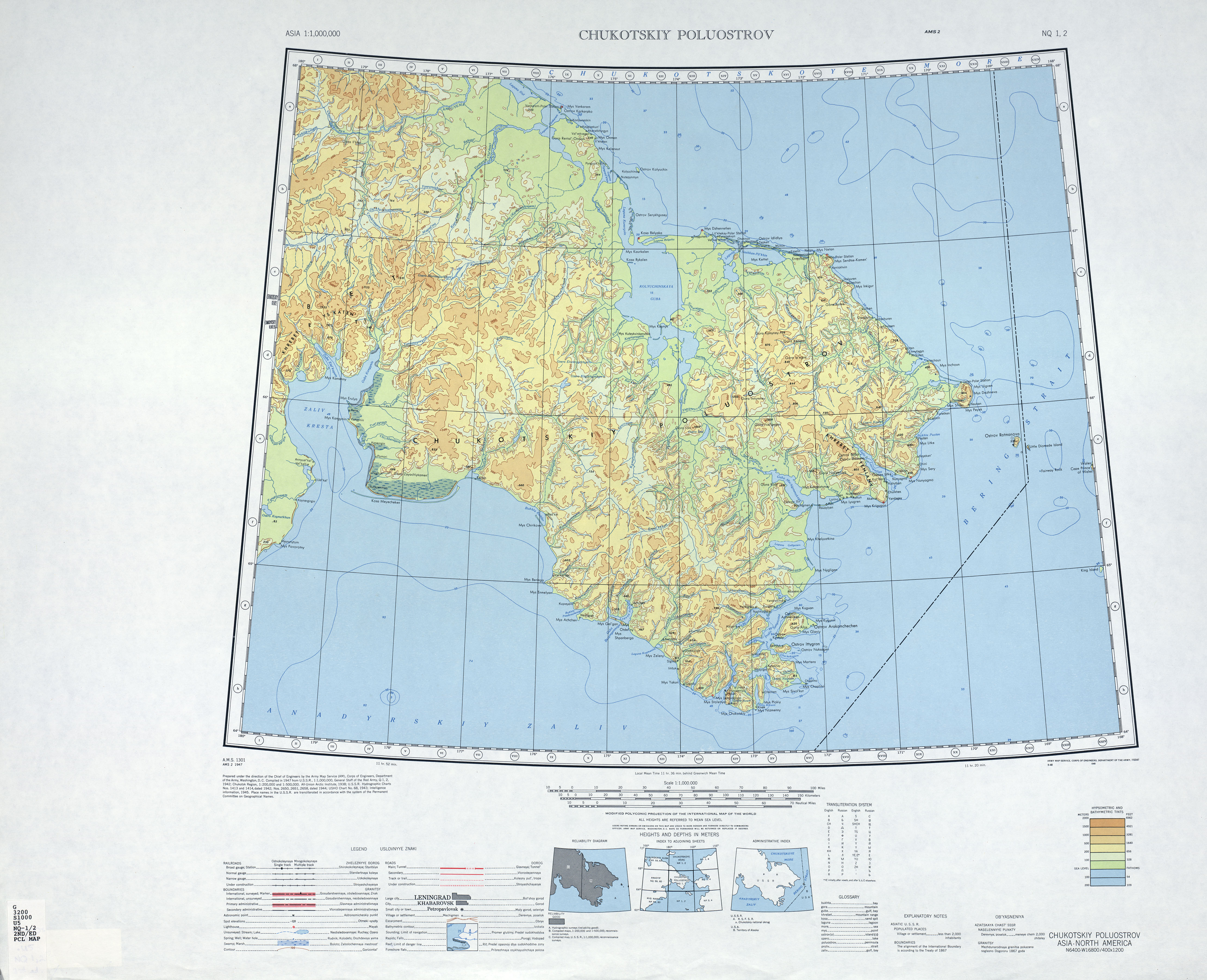
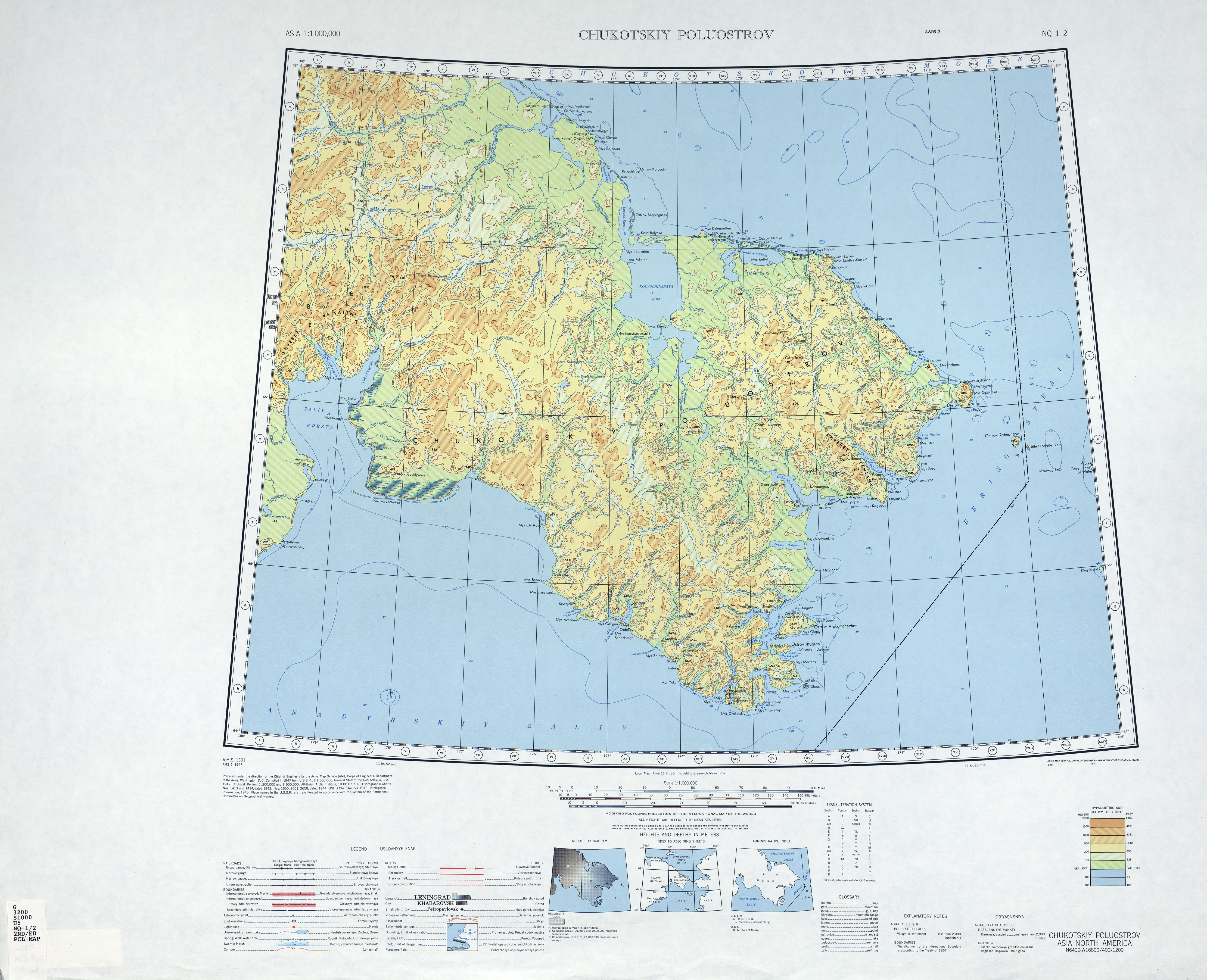
English: map of Chukchi peninsula, Russian Far East |
| Tarix | |
| Mənbə | http://www.lib.utexas.edu/maps/imw/txu-oclc-6654394-nq-1-2-2nd-ed.jpg |
| Müəllif | Army Map Service |
Lisenziya
This file is a work of a U.S. Army soldier or employee, taken or made as part of that person's official duties. As a work of the U.S. federal government, it is in the public domain in the United States.
|
 |
Faylın tarixçəsi
Faylın əvvəlki versiyasını görmək üçün gün/tarix bölməsindəki tarixlərə klikləyin.
| Tarix/Vaxt | Kiçik şəkil | Ölçülər | İstifadəçi | Şərh | |
|---|---|---|---|---|---|
| indiki | 21:22, 4 aprel 2010 | | 4.440 × 3.606 (3,42 MB) | Ratzer | {{Information |Description={{en|1=map of Chukchi peninsula, Russian Far East}} |Source=http://www.lib.utexas.edu/maps/imw/txu-oclc-6654394-nq-1-2-2nd-ed.jpg |Author=Army Map Service |Date=1947 |Permission= |other_versions= }} Category:Maps of Siberia |
Fayl keçidləri
Aşağıdakı səhifə bu faylı istifadə edir:
Faylın qlobal istifadəsi
Bu fayl aşağıdakı vikilərdə istifadə olunur:
- ar.wikipedia.org layihəsində istifadəsi
- ba.wikipedia.org layihəsində istifadəsi
- cs.wikipedia.org layihəsində istifadəsi
- de.wikipedia.org layihəsində istifadəsi
- en.wikipedia.org layihəsində istifadəsi
- es.wikipedia.org layihəsində istifadəsi
- et.wikipedia.org layihəsində istifadəsi
- he.wikipedia.org layihəsində istifadəsi
- hr.wikipedia.org layihəsində istifadəsi
- hsb.wikipedia.org layihəsində istifadəsi
- hy.wikipedia.org layihəsində istifadəsi
- ml.wikipedia.org layihəsində istifadəsi
- sr.wikipedia.org layihəsində istifadəsi
- sw.wikipedia.org layihəsində istifadəsi
- ta.wikipedia.org layihəsində istifadəsi
- uk.wikipedia.org layihəsində istifadəsi