Fayl:East China Sea Map.jpg
Daha yüksək versiyası yoxdur.
East_China_Sea_Map.jpg (600 × 533 piksel, fayl həcmi: 88 KB, MIME növü: image/jpeg)
| Bu fayl "Vikimedia Commons"dadır və digər layihələrdə istifadə edilə bilər. |
 |
Faylın təsvir səhifəsinə get |

|
This map image could be re-created using vector graphics as an SVG file. This has several advantages; see Commons:Media for cleanup for more information. If an SVG form of this image is available, please upload it and afterwards replace this template with
{{vector version available|new image name}}.
It is recommended to name the SVG file “East China Sea Map.svg”—then the template Vector version available (or Vva) does not need the new image name parameter. |


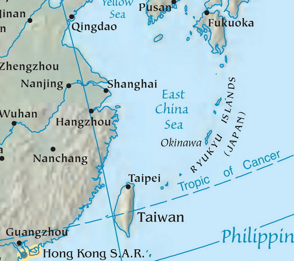
Map of the East China Sea. Mapa Východočínského moře (popisky v angličtině). Source: tr:Resim:DoğuÇinDenizi.jpg Licence: public domain, because it originally comes from the CIA World Factbook, i.e. from a United States federal governemental agency.
| |
This work has been released into the public domain by its author, Danbury, at the ingilis Vikipediya project. This applies worldwide. In case this is not legally possible: |
Faylın tarixçəsi
Faylın əvvəlki versiyasını görmək üçün gün/tarix bölməsindəki tarixlərə klikləyin.
| Tarix/Vaxt | Kiçik şəkil | Ölçülər | İstifadəçi | Şərh | |
|---|---|---|---|---|---|
| indiki | 13:26, 13 iyun 2007 | | 600 × 533 (88 KB) | Zeman | Map of the East China Sea. Mapa Východočínského moře (popisky v angličtině). Source: tr:Resim:DoğuÇinDenizi.jpg Licence: public domain, because it originally comes from the CIA World Factbook, i.e. from a United States federal governemental |
Fayl keçidləri
Bu faylı istifadə edən səhifə yoxdur.
Faylın qlobal istifadəsi
Bu fayl aşağıdakı vikilərdə istifadə olunur:
- ar.wikipedia.org layihəsində istifadəsi
- arz.wikipedia.org layihəsində istifadəsi
- bcl.wikipedia.org layihəsində istifadəsi
- be.wikipedia.org layihəsində istifadəsi
- bn.wikipedia.org layihəsində istifadəsi
- cdo.wikipedia.org layihəsində istifadəsi
- cs.wikipedia.org layihəsində istifadəsi
- en.wikipedia.org layihəsində istifadəsi
- eo.wikipedia.org layihəsində istifadəsi
- es.wikipedia.org layihəsində istifadəsi
- eu.wikipedia.org layihəsində istifadəsi
- fa.wikipedia.org layihəsində istifadəsi
- gl.wikipedia.org layihəsində istifadəsi
- he.wikipedia.org layihəsində istifadəsi
- hr.wikipedia.org layihəsində istifadəsi
- hy.wikipedia.org layihəsində istifadəsi
- id.wikipedia.org layihəsində istifadəsi
- ilo.wikipedia.org layihəsində istifadəsi
- incubator.wikimedia.org layihəsində istifadəsi
- is.wikipedia.org layihəsində istifadəsi
- it.wikipedia.org layihəsində istifadəsi
- ja.wikipedia.org layihəsində istifadəsi
- jv.wikipedia.org layihəsində istifadəsi
- kk.wikipedia.org layihəsində istifadəsi
- ko.wikipedia.org layihəsində istifadəsi
- lt.wikipedia.org layihəsində istifadəsi
- mk.wikipedia.org layihəsində istifadəsi
- ml.wikipedia.org layihəsində istifadəsi
- ms.wikipedia.org layihəsində istifadəsi
- no.wikipedia.org layihəsində istifadəsi
- pa.wikipedia.org layihəsində istifadəsi
- pl.wiktionary.org layihəsində istifadəsi
- pt.wikipedia.org layihəsində istifadəsi
- ro.wikipedia.org layihəsində istifadəsi
- ru.wikipedia.org layihəsində istifadəsi
- ru.wikinews.org layihəsində istifadəsi
Bu faylın qlobal istifadəsinə baxın.