Fayl:Historical map of the Balkans around 582-612 AD.jpg
Faylın orijinalı (1.688 × 1.977 piksel, fayl həcmi: 476 KB, MIME növü: image/jpeg)
| Bu fayl "Vikimedia Commons"dadır və digər layihələrdə istifadə edilə bilər. |
 |
Faylın təsvir səhifəsinə get |
Xülasə
| Description |
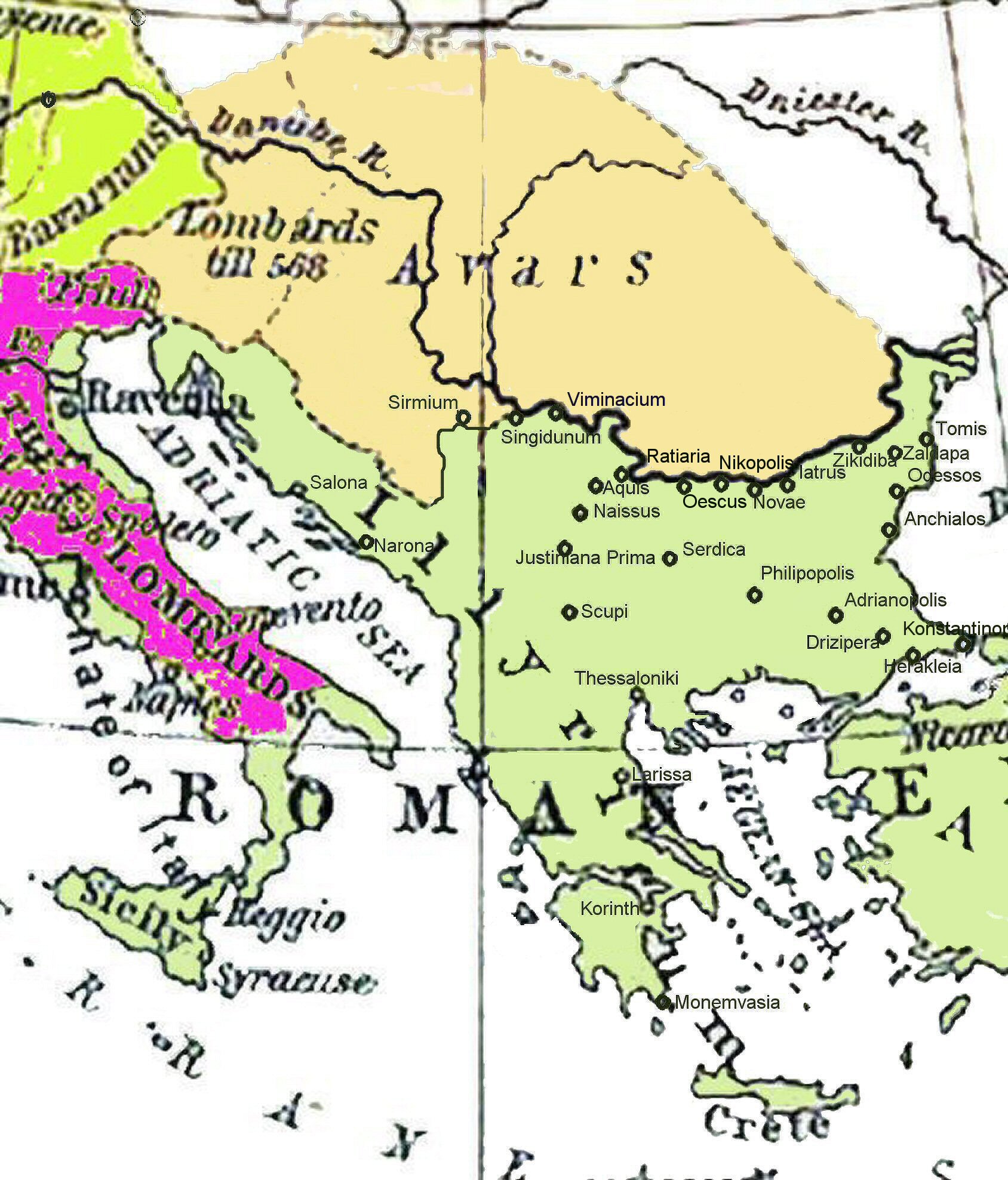
Български: Балканския Полуостров 582-612.
Deutsch: Diese Karte gibt einen Überblick über den Balkan zur Zeit der Kaiser Maurikios und Phokas, insbesondere über die Städte, in deren Umgebung die Kampfhandlungen während der Balkanfeldzüge des Maurikios statt fanden. Das Reich der Awaren. Der Balkan 582-612.
English: Historical map of the Balkans around 582-612 AD showing the Avar Khaganate, Byzantine (Eastern Roman) Empire.
Español: Mapa mostrando la localización del Jaganato de los Ávaros hacia 600 d. C.
Italiano: Il khaganato avaro dal 582 al 615 circa. La locazione del khanato Avaro verso il 600. I Balcani dal 582 al 615.
日本語: 600年頃のアヴァール(Avars)と東ローマ(ROMAN EMPIRE)。.
Română: Imperiul Avar.
Srpskohrvatski / српскохрватски: Balkan 582-612.
Slovenščina: Karta Balkana okoli leta 600.
Shqip: Ballkani në vitet 582 – 612 para dyndjeve sllave. Der Balkan 582–612.
Svenska: Avarernas rike på 600-talet.
ไทย: แผนที่แสดงตำแหน่งของอาณาจักรข่านของอาวาร์ราว ค.ศ. 600.
Türkçe: 600'lü yıllarda Avar Kağanlığı. 600'lü yıllarda Avar toprakları. |
| Tarix | 04.11.2006 |
| Mənbə | Ursprung Shepherd, William: Historical Atlas. New York: Henry Holt and Company, 1911 |
| Yaradıcı |
William Shepherd R. (1871-1934); Wolf Halama (nur der hier überarbeitete Kartenausschnitt) |
| Georeferencing | If inappropriate please set warp_status = skip to hide. |
Lisenziya
|
This work is in the public domain in its country of origin and other countries and areas where the copyright term is the author's life plus 70 years or fewer.
| |
| This file has been identified as being free of known restrictions under copyright law, including all related and neighboring rights. | |
Orijinal yükləmə gündəliyi
Transferred from de.wikipedia to Commons by Roberta F. using CommonsHelper.
- 2007-04-14 10:29 Hungerhahn 1688×1977× (487589 bytes) {{Information |Beschreibung = |Quelle = |Urheber = |Datum = |Genehmigung = |Andere Versionen = |Anmerkungen = }}
- 2007-03-16 19:01 Hungerhahn 1688×1977× (477133 bytes) {{Information |Beschreibung = |Quelle = |Urheber = |Datum = |Genehmigung = |Andere_Versionen = |Anmerkungen = }}
- 2007-03-16 18:58 Hungerhahn 1688×1977× (477133 bytes) {{Information |Beschreibung = |Quelle = |Urheber = |Datum = |Genehmigung = |Andere_Versionen = |Anmerkungen = }}
- 2007-03-16 18:55 Hungerhahn 1688×1977× (477133 bytes) {{Information |Beschreibung = |Quelle = |Urheber = |Datum = |Genehmigung = |Andere_Versionen = |Anmerkungen = }}
- 2006-11-04 18:51 Hungerhahn 1688×1977× (474804 bytes) {{Information |Beschreibung= Der Balkan Ende des 6. Jahrhunderts |Quelle= |Urheber=Wolf Halama |Datum=04.11.2006 |Genehmigung= |Andere Versionen= |Anmerkungen= }}
Faylın tarixçəsi
Faylın əvvəlki versiyasını görmək üçün gün/tarix bölməsindəki tarixlərə klikləyin.
| Tarix/Vaxt | Kiçik şəkil | Ölçülər | İstifadəçi | Şərh | |
|---|---|---|---|---|---|
| indiki | 16:43, 9 avqust 2009 | | 1.688 × 1.977 (476 KB) | File Upload Bot (Magnus Manske) | {{BotMoveToCommons|de.wikipedia|year={{subst:CURRENTYEAR}}|month={{subst:CURRENTMONTHNAME}}|day={{subst:CURRENTDAY}}}} {{Information |Description={{de|Diese Karte gibt einen Überblick über den Balkan zur Zeit der Kaiser de:Maurikios und [[:de:Pho |
Fayl keçidləri
Bu faylı istifadə edən səhifə yoxdur.
Faylın qlobal istifadəsi
Bu fayl aşağıdakı vikilərdə istifadə olunur:
- als.wikipedia.org layihəsində istifadəsi
- ast.wikipedia.org layihəsində istifadəsi
- azb.wikipedia.org layihəsində istifadəsi
- az.wiktionary.org layihəsində istifadəsi
- be.wikipedia.org layihəsində istifadəsi
- bg.wikipedia.org layihəsində istifadəsi
- cs.wikipedia.org layihəsində istifadəsi
- da.wikipedia.org layihəsində istifadəsi
- de.wikipedia.org layihəsində istifadəsi
- dsb.wikipedia.org layihəsində istifadəsi
- el.wikipedia.org layihəsində istifadəsi
- en.wikipedia.org layihəsində istifadəsi
- et.wikipedia.org layihəsində istifadəsi
- fa.wikipedia.org layihəsində istifadəsi
- fr.wikipedia.org layihəsində istifadəsi
- hr.wikipedia.org layihəsində istifadəsi
Bu faylın qlobal istifadəsinə baxın.