Fayl:ISmap.svg

Bu SVG-faylın PNG formatındakı bu görünüşünün ölçüsü: 374 × 599 piksel. Digər ölçülər: 150 × 240 piksel | 300 × 480 piksel | 480 × 768 piksel | 639 × 1.024 piksel | 1.279 × 2.048 piksel | 1.075 × 1.721 piksel.
Faylın orijinalı (SVG faylı, nominal olaraq 1.075 × 1.721 piksel, faylın ölçüsü: 1,29 MB)
| Bu fayl "Vikimedia Commons"dadır və digər layihələrdə istifadə edilə bilər. |
 |
Faylın təsvir səhifəsinə get |
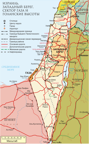
| İzah | Карта Израиля, палестинских территорий, Голанских высот. Также показана территория расположения миротворческих сил ООН по состоянию на январь 2004 |
| Tarix | (UTC) |
| Mənbə | |
| Müəllif |
|

|
This work is free software; you can redistribute it and/or modify it under the terms of the GNU General Public License as published by the Free Software Foundation; either version 2 of the License, or any later version. This work is distributed in the hope that it will be useful, but without any warranty; without even the implied warranty of merchantability or fitness for a particular purpose. See version 2 and version 3 of the GNU General Public License for more details. |
Faylın tarixçəsi
Faylın əvvəlki versiyasını görmək üçün gün/tarix bölməsindəki tarixlərə klikləyin.
| Tarix/Vaxt | Kiçik şəkil | Ölçülər | İstifadəçi | Şərh | |
|---|---|---|---|---|---|
| indiki | 04:34, 9 avqust 2011 | | 1.075 × 1.721 (1,29 MB) | Express2000 | Уменьшен размер |
| 04:23, 9 avqust 2011 |  | 1.075 × 1.721 (1,63 MB) | Express2000 | {{Information |Description=Карта Израиля, палестинских территорий, Голанских высот. Также показана территория расположения миротворческих сил ООН по � |
Fayl keçidləri
Aşağıdakı səhifə bu faylı istifadə edir:
Faylın qlobal istifadəsi
Bu fayl aşağıdakı vikilərdə istifadə olunur:
- kk.wikipedia.org layihəsində istifadəsi
- ru.wikipedia.org layihəsində istifadəsi