Fayl:Ottoman Provinces Of Present day Libya.png
Daha yüksək versiyası yoxdur.
Ottoman_Provinces_Of_Present_day_Libya.png (282 × 314 piksel, fayl həcmi: 22 KB, MIME növü: image/png)
| Bu fayl "Vikimedia Commons"dadır və digər layihələrdə istifadə edilə bilər. |
 |
Faylın təsvir səhifəsinə get |

|
This locator map image could be re-created using vector graphics as an SVG file. This has several advantages; see Commons:Media for cleanup for more information. If an SVG form of this image is available, please upload it and afterwards replace this template with
{{vector version available|new image name}}.
It is recommended to name the SVG file “Ottoman Provinces Of Present day Libya.svg”—then the template Vector version available (or Vva) does not need the new image name parameter. |
Xülasə
| İzah |
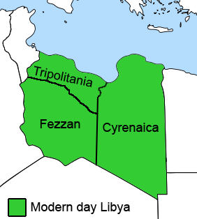
English: The Ottoman Turks conquered the country in the mid-16th century, and the three States or "Wilayat" of Tripolitania, Cyrenaica and Fezzan (which make up Libya) remained part of their empire with the exception of the virtual autonomy of the Karamanlis. The Karamanlis ruled from 1711 until 1835 mainly in Tripolitania, but had influence in Cyrenaica and Fezzan as well by the mid 18th century. |
||
| Tarix | |||
| Mənbə | self-made but based on this image on this image and this image | ||
| Müəllif | Esemono; improved by Kirk (talk) | ||
| İcazə (Faylın təkrar istifadəsi) |
|
||
| Digər versiyalar |
Derivative works of this file:
   |
Faylın tarixçəsi
Faylın əvvəlki versiyasını görmək üçün gün/tarix bölməsindəki tarixlərə klikləyin.
| Tarix/Vaxt | Kiçik şəkil | Ölçülər | İstifadəçi | Şərh | |
|---|---|---|---|---|---|
| indiki | 12:53, 24 avqust 2011 | | 282 × 314 (22 KB) | Kirk979 | See discussion |
| 20:46, 11 aprel 2011 |  | 300 × 350 (35 KB) | ANGELUS | border | |
| 20:35, 11 aprel 2011 |  | 300 × 350 (39 KB) | ANGELUS | improved | |
| 17:35, 12 oktyabr 2009 |  | 282 × 314 (22 KB) | Kirk979 | corrections | |
| 11:00, 1 mart 2009 |  | 282 × 314 (29 KB) | Kirk979 | corrections | |
| 13:43, 17 aprel 2008 |  | 282 × 314 (25 KB) | Esemono | Category:Maps of Libya Category:Map images that should use vector graphics |
Fayl keçidləri
Aşağıdakı səhifə bu faylı istifadə edir:
Faylın qlobal istifadəsi
Bu fayl aşağıdakı vikilərdə istifadə olunur:
- ar.wikipedia.org layihəsində istifadəsi
- azb.wikipedia.org layihəsində istifadəsi
- be.wikipedia.org layihəsində istifadəsi
- bg.wikipedia.org layihəsində istifadəsi
- bs.wikipedia.org layihəsində istifadəsi
- ca.wikipedia.org layihəsində istifadəsi
- cs.wikipedia.org layihəsində istifadəsi
- da.wikipedia.org layihəsində istifadəsi
- el.wikipedia.org layihəsində istifadəsi
- en.wikipedia.org layihəsində istifadəsi
- Cyrenaica
- Districts of Libya
- Fezzan
- Tripolitania
- Governorates of Libya
- Subdivisions of Libya
- Provinces of Libya
- Postage stamps and postal history of Tripolitania
- Kingdom of Libya
- Postage stamps and postal history of Cyrenaica
- Postage stamps and postal history of Libya
- Postage stamps and postal history of Fezzan and Ghadames
- Template:Regions of Libya
- Category:Regions of Libya
- Revenue stamps of Libya
- Tripolitania (province of Libya)
- Cyrenaica province
- Fezzan province
- eo.wikipedia.org layihəsində istifadəsi
Bu faylın qlobal istifadəsinə baxın.