Fayl:ShepherdByzempire1265.jpg
Faylın orijinalı (1.144 × 900 piksel, fayl həcmi: 281 KB, MIME növü: image/jpeg)
| Bu fayl "Vikimedia Commons"dadır və digər layihələrdə istifadə edilə bilər. |
 |
Faylın təsvir səhifəsinə get |
Xülasə
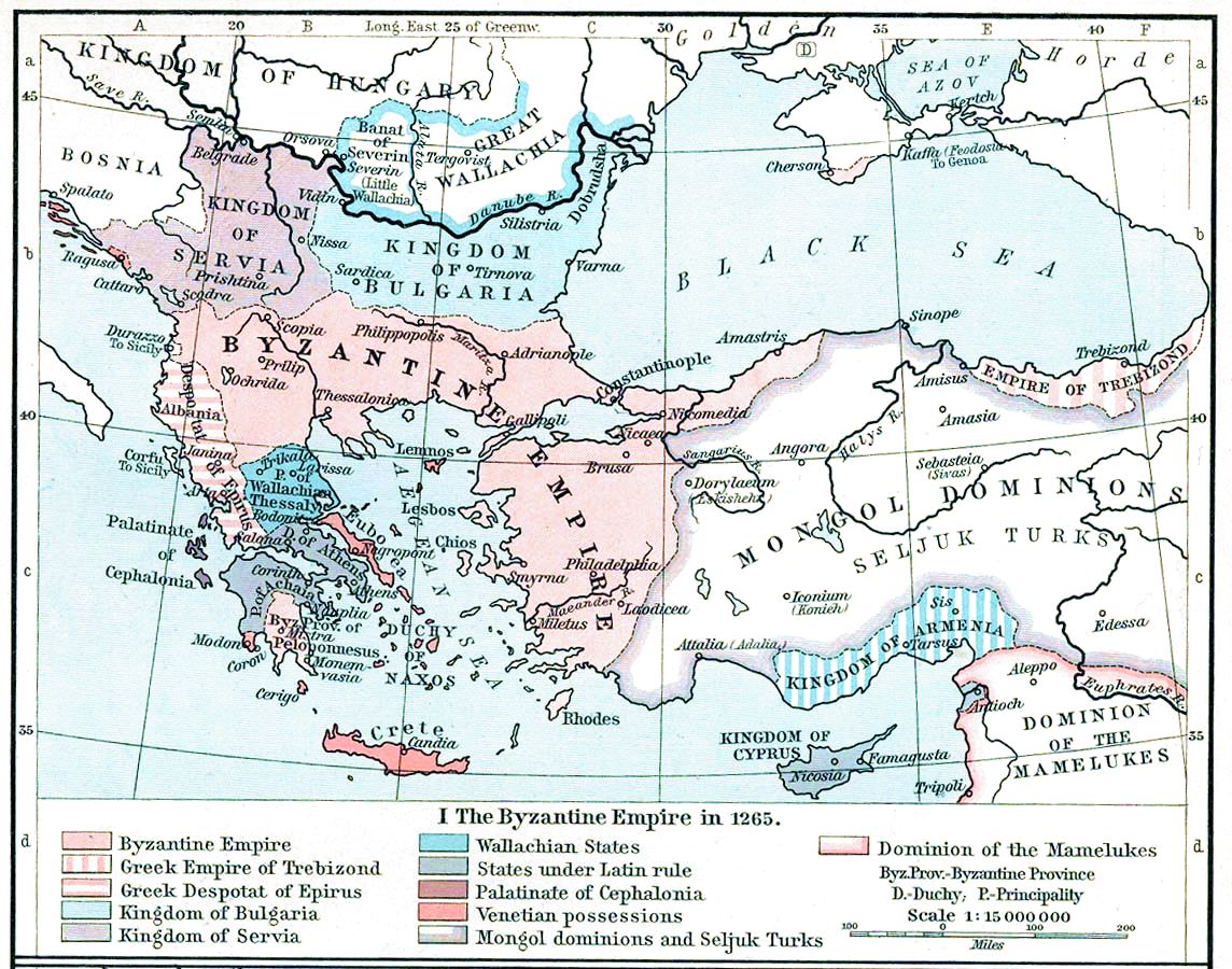
| İzah | Map, The Byzantine Empire, 1265. | ||||||||||||||||||||||
| Tarix | |||||||||||||||||||||||
| Mənbə | The Historical Atlas, William R. Shepherd, 1911. | ||||||||||||||||||||||
| Müəllif |
|
||||||||||||||||||||||
| Digər versiyalar |
Derivative works of this file: |
||||||||||||||||||||||

|
This old map image could be re-created using vector graphics as an SVG file. This has several advantages; see Commons:Media for cleanup for more information. If an SVG form of this image is available, please upload it and afterwards replace this template with
{{vector version available|new image name}}.
It is recommended to name the SVG file “ShepherdByzempire1265.svg”—then the template Vector version available (or Vva) does not need the new image name parameter. |


Lisenziya
|
This work is in the public domain in its country of origin and other countries and areas where the copyright term is the author's life plus 70 years or fewer.
| |
| This file has been identified as being free of known restrictions under copyright law, including all related and neighboring rights. | |
This media file is in the public domain in the United States. This applies to U.S. works where the copyright has expired, often because its first publication occurred prior to January 1, 1929, and if not then due to lack of notice or renewal. See this page for further explanation.
|
 | |
 |
This image might not be in the public domain outside of the United States; this especially applies in the countries and areas that do not apply the rule of the shorter term for US works, such as Canada, Mainland China (not Hong Kong or Macao), Germany, Mexico, and Switzerland. The creator and year of publication are essential information and must be provided. See Wikipedia:Public domain and Wikipedia:Copyrights for more details.
|
Faylın tarixçəsi
Faylın əvvəlki versiyasını görmək üçün gün/tarix bölməsindəki tarixlərə klikləyin.
| Tarix/Vaxt | Kiçik şəkil | Ölçülər | İstifadəçi | Şərh | |
|---|---|---|---|---|---|
| indiki | 15:28, 16 noyabr 2022 | | 1.144 × 900 (281 KB) | Gyalu22 | Reverted to version as of 16:26, 12 July 2009 (UTC) |
| 14:49, 20 may 2016 |  | 1.144 × 900 (858 KB) | Julieta39 | Cosmetic (see discussion file) | |
| 16:26, 12 iyul 2009 |  | 1.144 × 900 (281 KB) | Alex:D | whitened | |
| 16:17, 12 iyul 2009 |  | 1.144 × 900 (281 KB) | Alex:D | whitened | |
| 16:12, 12 iyul 2009 |  | 1.144 × 900 (281 KB) | Alex:D | whitened | |
| 13:40, 21 dekabr 2004 |  | 1.144 × 900 (272 KB) | Mschlindwein | Map, The Byzantine Empire, 1265. The Historical Atlas, William R. Shepherd, 1911. |
Fayl keçidləri
Aşağıdakı 2 səhifə bu faylı istifadə edir:
Faylın qlobal istifadəsi
Bu fayl aşağıdakı vikilərdə istifadə olunur:
- an.wikipedia.org layihəsində istifadəsi
- ar.wikipedia.org layihəsində istifadəsi
- azb.wikipedia.org layihəsində istifadəsi
- be-tarask.wikipedia.org layihəsində istifadəsi
- be.wikipedia.org layihəsində istifadəsi
- bg.wikipedia.org layihəsində istifadəsi
- ca.wikipedia.org layihəsində istifadəsi
- cs.wikipedia.org layihəsində istifadəsi
- de.wikipedia.org layihəsində istifadəsi
- el.wikipedia.org layihəsində istifadəsi
- en.wikipedia.org layihəsində istifadəsi
Bu faylın qlobal istifadəsinə baxın.