Fayl:South Shetland Islands Map.png
Sınaq göstərişi ölçüsü: 800 × 551 piksel. Digər ölçülər: 320 × 220 piksel | 640 × 441 piksel | 1.103 × 760 piksel.
Faylın orijinalı (1.103 × 760 piksel, fayl həcmi: 35 KB, MIME növü: image/png)
| Bu fayl "Vikimedia Commons"dadır və digər layihələrdə istifadə edilə bilər. |
 |
Faylın təsvir səhifəsinə get |
| İzah |
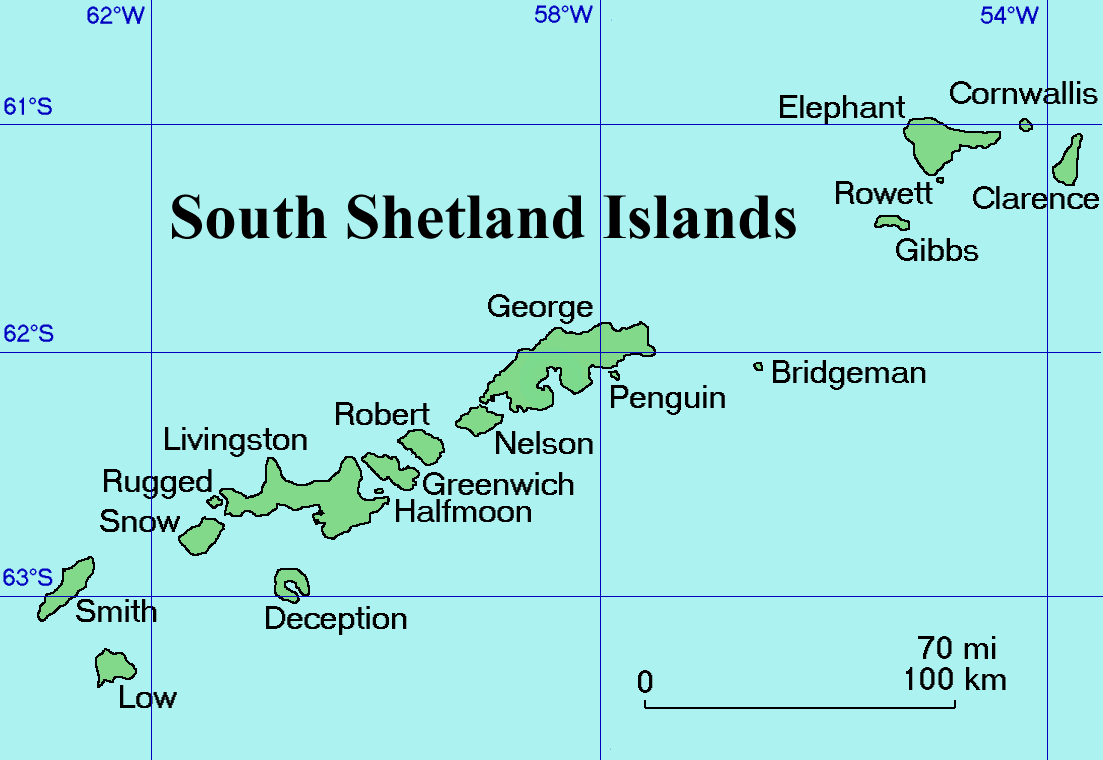
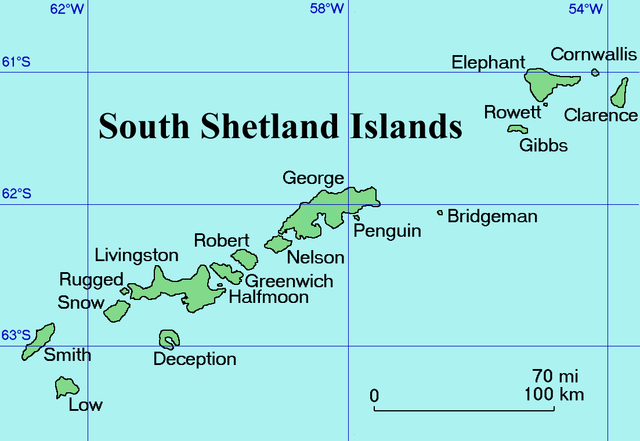
English: Map of the South Shetland Islands
Català: Mapa de les illes Shetland del Sud.
Deutsch: Karte der Südlichen Shetlandinseln
Español: Mapa de las Islas Shetland del Sur
Italiano: Una mappa delle Isole Shetland Meridionali
Русский: Карта Южных Шетландских островов (английский вариант)
Slovenščina: Zemljevid otočja |
| Tarix | Commons upload by Snowdog |
| Mənbə |
Originally from en.wikipedia; description page is (was) here
|
| Müəllif | User Topbanana on en.wikipedia |
| İcazə (Faylın təkrar istifadəsi) |
PD-self |
| |
This work has been released into the public domain by its author, Topbanana, at the ingilis Vikipediya project. This applies worldwide. In case this is not legally possible: |
Faylın tarixçəsi
Faylın əvvəlki versiyasını görmək üçün gün/tarix bölməsindəki tarixlərə klikləyin.
| Tarix/Vaxt | Kiçik şəkil | Ölçülər | İstifadəçi | Şərh | |
|---|---|---|---|---|---|
| indiki | 20:11, 27 fevral 2005 | | 1.103 × 760 (35 KB) | Snowdog | Map of the South Shetland Islands |
Fayl keçidləri
Aşağıdakı 4 səhifə bu faylı istifadə edir:
Faylın qlobal istifadəsi
Bu fayl aşağıdakı vikilərdə istifadə olunur:
- af.wikipedia.org layihəsində istifadəsi
- ang.wikipedia.org layihəsində istifadəsi
- ar.wikipedia.org layihəsində istifadəsi
- ast.wikipedia.org layihəsində istifadəsi
- ba.wikipedia.org layihəsində istifadəsi
- be.wikipedia.org layihəsində istifadəsi
- bg.wikipedia.org layihəsində istifadəsi
- br.wikipedia.org layihəsində istifadəsi
- ca.wikipedia.org layihəsində istifadəsi
- ceb.wikipedia.org layihəsində istifadəsi
- ce.wikipedia.org layihəsində istifadəsi
- cs.wikipedia.org layihəsində istifadəsi
- cv.wikipedia.org layihəsində istifadəsi
- da.wikipedia.org layihəsində istifadəsi
- de.wikipedia.org layihəsində istifadəsi
- el.wikipedia.org layihəsində istifadəsi
- en.wikipedia.org layihəsində istifadəsi
- South Shetland Islands
- Gibbs Island (South Shetland Islands)
- Clarence Island (South Shetland Islands)
- Cornwallis Island (South Shetland Islands)
- Seal Islands (South Shetland Islands)
- Benjamin Morrell
- Endurance Point
- Cape Bowles
- Chinstrap Cove
- Walker Point
- Jubilee Peak
- Sultan Glacier
- Furness Glacier
- Gnomon Island
- Cape Lloyd
- Highton Glacier
- Ravelin Ridge
- Cape Valentine
- Wordie Seamount
- Chichil Point
- Soyka Saddle
- Urda Ridge
- Duclos-Guyot Bluff
Bu faylın qlobal istifadəsinə baxın.