Fayl:Un-myanmar.png
Faylın orijinalı (2.366 × 3.092 piksel, fayl həcmi: 1,83 MB, MIME növü: image/png)
| Bu fayl "Vikimedia Commons"dadır və digər layihələrdə istifadə edilə bilər. |
 |
Faylın təsvir səhifəsinə get |
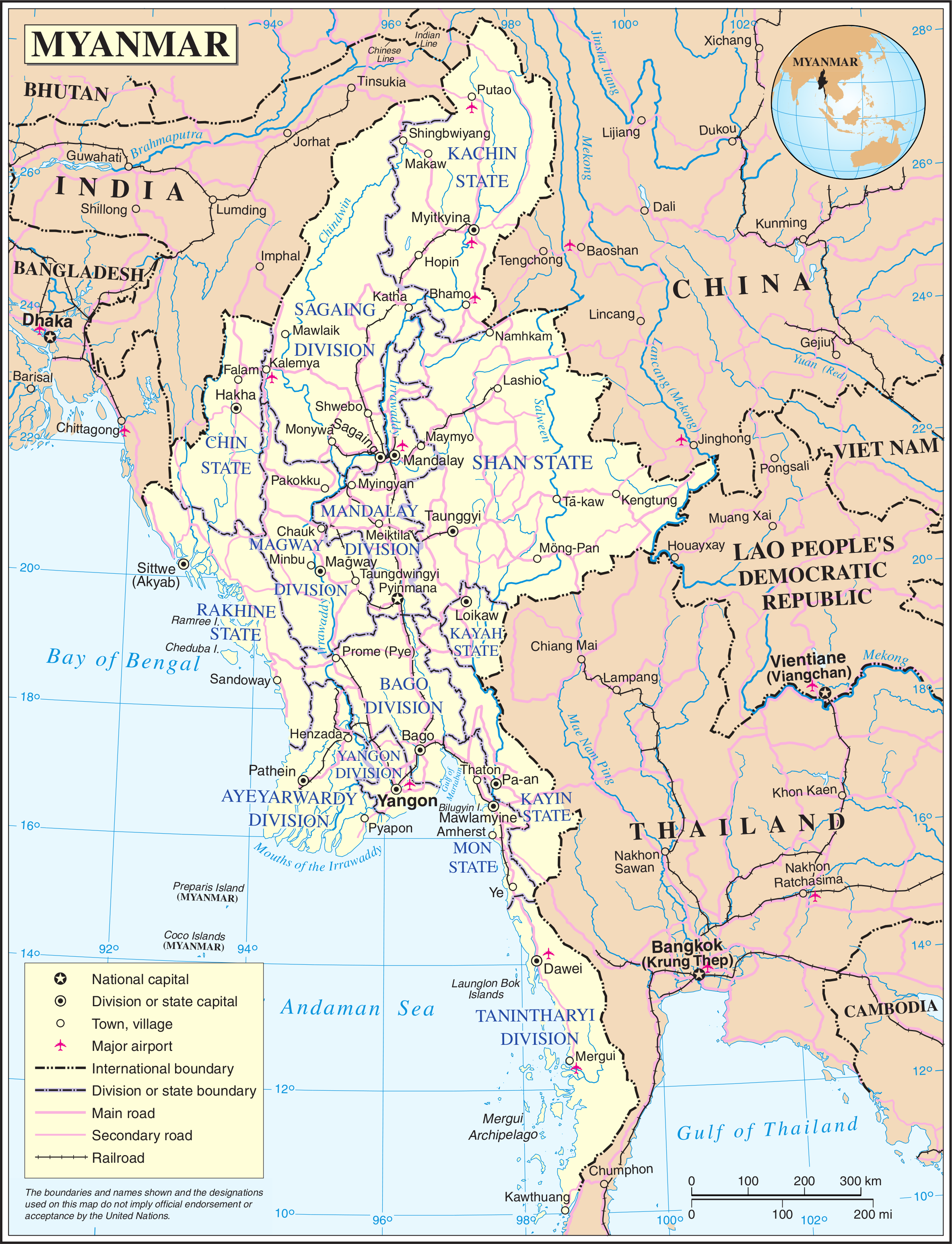
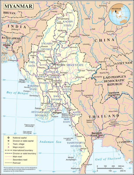
Map of Myanmar. Based on the UN map, but the location capital has been updated by me (the original uploader).
| This image is a map derived from a United Nations map.
Unless stated otherwise, UN maps are to be considered in the public domain. This applies worldwide. UN maps are, in principle, open source material and you can use them in your work or for making your own map. UN requests however that you delete the UN name, logo and reference number upon any modification to the map. Content of your map will be your responsibility. You can state in your publication, if you wish, something like: based on UN map … (map name, map number, revision number and date). See: Geospatial Information Section. And: Geospatial, location data for a better world. |
 |
Faylın tarixçəsi
Faylın əvvəlki versiyasını görmək üçün gün/tarix bölməsindəki tarixlərə klikləyin.
| Tarix/Vaxt | Kiçik şəkil | Ölçülər | İstifadəçi | Şərh | |
|---|---|---|---|---|---|
| indiki | 21:11, 13 may 2008 | | 2.366 × 3.092 (1,83 MB) | Mahahahaneapneap | Compressed |
| 01:36, 24 oktyabr 2007 |  | 2.366 × 3.092 (2,42 MB) | Jeroen | Map of Myanmar. Based on the UN map, but the location capital has been updated by me (the original uploader). {{UN map}} Category:Maps of Myanmar |
Fayl keçidləri
Aşağıdakı səhifə bu faylı istifadə edir:
Faylın qlobal istifadəsi
Bu fayl aşağıdakı vikilərdə istifadə olunur:
- bn.wikipedia.org layihəsində istifadəsi
- en.wikipedia.org layihəsində istifadəsi
- fi.wikipedia.org layihəsində istifadəsi
- fr.wikipedia.org layihəsində istifadəsi
- gl.wikipedia.org layihəsində istifadəsi
- kg.wikipedia.org layihəsində istifadəsi
- pl.wiktionary.org layihəsində istifadəsi
- shn.wikipedia.org layihəsində istifadəsi
- simple.wikipedia.org layihəsində istifadəsi
- si.wikipedia.org layihəsində istifadəsi
- sl.wikipedia.org layihəsində istifadəsi
- uk.wikipedia.org layihəsində istifadəsi
- zh.wikipedia.org layihəsində istifadəsi