Fayl:Utrecht position.svg

Bu SVG-faylın PNG formatındakı bu görünüşünün ölçüsü: 200 × 236 piksel. Digər ölçülər: 203 × 240 piksel | 407 × 480 piksel | 651 × 768 piksel | 868 × 1.024 piksel | 1.736 × 2.048 piksel.
Faylın orijinalı (SVG faylı, nominal olaraq 200 × 236 piksel, faylın ölçüsü: 157 KB)
| Bu fayl "Vikimedia Commons"dadır və digər layihələrdə istifadə edilə bilər. |
 |
Faylın təsvir səhifəsinə get |
Xülasə
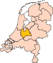
| İzah | Location of the province of Utrecht in the Netherlands. |
| Tarix | |
| Mənbə | Own work, based on freely available GIS data |
| Müəllif | User:Mtcv |
| İcazə (Faylın təkrar istifadəsi) |
Data: attribution required; my work: PD |
| Digər versiyalar | I attempted to make an svg version of Image:Utrecht-Position.png (with less simplified boundaries) |
Clickable version

Lisenziya

|
The copyright holder of this file, Centraal Bureau voor de Statistiek, allows anyone to use it for any purpose, provided that the copyright holder is properly attributed. Redistribution, derivative work, commercial use, and all other use is permitted. |
İstinad:
|
| Annotations | This image is annotated: View the annotations at Commons |


Faylın tarixçəsi
Faylın əvvəlki versiyasını görmək üçün gün/tarix bölməsindəki tarixlərə klikləyin.
| Tarix/Vaxt | Kiçik şəkil | Ölçülər | İstifadəçi | Şərh | |
|---|---|---|---|---|---|
| indiki | 17:20, 2 mart 2019 | | 200 × 236 (157 KB) | Thayts | update |
| 00:49, 3 oktyabr 2006 |  | 200 × 236 (158 KB) | Mtcv | {{Information| |Description=Location of the province of Noord-Holland (North Holland) in the Netherlands. |Source=Own work, based on freely available GIS data |Date=2006-10-03 |Author=User:Mtcv |Permission=Data: attribution required; my work: PD |othe |
Fayl keçidləri
Bu faylı istifadə edən səhifə yoxdur.
Faylın qlobal istifadəsi
Bu fayl aşağıdakı vikilərdə istifadə olunur:
- ar.wikipedia.org layihəsində istifadəsi
- be-tarask.wikipedia.org layihəsində istifadəsi
- be.wikipedia.org layihəsində istifadəsi
- cy.wikipedia.org layihəsində istifadəsi
- en.wikipedia.org layihəsində istifadəsi
Bu faylın qlobal istifadəsinə baxın.