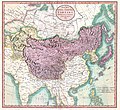
Fayl:1806 Cary Map of Tartary or Central Asia - Geographicus - Tartary-cary-1806.jpg

Faylın orijinalı(5.000 × 4.569 piksel, fayl həcmi: 8,57 MB, MIME növü: image/jpeg)

Bu fayl "Vikimedia Commons"dadır
və digər layihələrdə istifadə edilə bilər.
təsvir səhifəsi
təsvir səhifəsi
Faylın təsvir səhifəsinə get
John Cary: A New Map of Mongolian & Independent Tartary , From the Latest Authorities.   (Wikidata search (Cirrus search) Wikidata query (SPARQL)  Create new Wikidata item based on this file)
Artist
John Cary  (–1835)  wikidata:Q3446124 s:en:Author:John Cary
 
Alternativ adlar
J. Cary
İzah xəritəşünas, qravüraçı, mapseller, printseller və qrafika ustası
Doğum/ölüm tarixi 23 fevral 1755 / 1754 Vikidatada redaktə et 16 avqust 1835 Vikidatada redaktə et
Doğum/ölüm yeri Corsley Mortlake
Yaradıcılıq illəri 1788 / 1793 / 1797 Vikidatada redaktə et
Yaradıcılıq məkanı
Normativ yoxlama
artist QS:P170,Q3446124
Başlıq
A New Map of Mongolian & Independent Tartary , From the Latest Authorities.
İzah
English: An exceptionally beautiful example of John Cary’s important 1806 map of Mongolian and Independent Tartary. Covers Central Asia from the Caspian Sea to Japan, extends as far north as the Obskaia Sea and as far south as India, Burma and the Philippines. Includes the modern day nations of Uzbekistan, Kazakhstan, Turkmenistan, Kirgizstan, Tajikistan and Mongolia. One of Cary’s most interesting maps. Central Asia, despite hundreds of years of passing trade on the Silk Routes, was still, at the turn of the century a largely unknown land. Cary attempts to show some of the Silk Route passages, especially to the north of the Gobi, but ultimately admits, “The Geography of these parts is extremely obscure.” All in all, one of the most interesting and few maps of Central Asia to appear in first years of the 19th century. Prepared in 1806 by John Cary for issue in his magnificent 1808 New Universal Atlas. (NOTE: The reproduction of the colors in this map appear to be incorrect, as Japan and Tibet were never part of Chinese Tartary yet appear to be the same color as it.)
Tarix 1806 (dated)
Ölçülər Hündürlük: 18,5 düym (46,9 sm); eni: 20 düym (50,8 sm)
dimensions QS:P2048,18.5U218593
dimensions QS:P2049,20U218593
Accession number
Geographicus link: Tartary-cary-1806
Source/Photographer

Cary, John, Cary's New Universal Atlas, containing distinct maps of all the principal states and kingdoms throughout the World. From the latest and best authorities extant. London: Printed for J. Cary, Engraver and Map-seller, No. 181, near Norfolk Street, Strand, 1808.

İcazə
(Faylın təkrar istifadəsi)
Bu şəkil, təsviri incəsənət əsərinin orijinal ikiölçülü dəqiq fotoqrafiya reproduksiyasıdır. Təsviri incəsənətin bu əsəri öz-özlüyündə aşağıdakı səbəblərdən ictimai varidat sayılır:
Public domain

This work is in the public domain in its country of origin and other countries and areas where the copyright term is the author's life plus 100 years or fewer.


You must also include a United States public domain tag to indicate why this work is in the public domain in the United States.
"Vikimedia Fondu" tutduğu rəsmi mövqe ondan ibarətdir ki, "ictimai varidat olan təsviri incəsənət əsərlərinin ikiölçülü dəqiq reproduksiyaları da ictimai varidat sayılır". Ətraflı məlumat almaq üçün Commons:When to use the PD-Art tag məqaləsinə baxın.
Beləliklə bu fotoqrafiya reproduksiyası ictimai varidat hesab edilir. Xahiş edirik nəzərə alın ki, yerli qanunvericilikdən asılı olaraq bu məzmunun təkrar istifadəsi qadağandır və ya sizin yurisdiksiyanızda bu məzmun məhdudlaşdırılmış ola bilər. Commons:Reuse of PD-Art photographs məqaləsinə baxın.
Digər versiyalar
Annotations
InfoField
This image is annotated: View the annotations at Commons

Captions

Add a one-line explanation of what this file represents

Items portrayed in this file

təsvir edir

MIME type ingilis

image/jpeg

checksum ingilis

3d7f1be3ae7a9539d26d91394bee37e7dc951779

data size ingilis

8.990.511 Bayt

5.000 piksel

Faylın tarixçəsi

Faylın əvvəlki versiyasını görmək üçün gün/tarix bölməsindəki tarixlərə klikləyin.

Tarix/VaxtKiçik şəkilÖlçülərİstifadəçiŞərh
indiki08:56, 19 avqust 201908:56, 19 avqust 2019 tarixindəki versiyanın kiçildilmiş görüntüsü5.000 × 4.569 (8,57 MB)SoerfmBrightness, color
10:56, 22 mart 201110:56, 22 mart 2011 tarixindəki versiyanın kiçildilmiş görüntüsü5.000 × 4.569 (7,81 MB)BotMultichillT{{subst:User:Multichill/Geographicus |link=http://www.geographicus.com/P/AntiqueMap/Tartary-cary-1806 |product_name=1806 Cary Map of Tartary or Central Asia |map_title=A New Map of Chinese & Independent Tartary , From the Latest Authorities. |description=

Aşağıdakı səhifə bu faylı istifadə edir:

Faylın qlobal istifadəsi

Bu fayl aşağıdakı vikilərdə istifadə olunur:

Metaməlumatlar