Fayl:Achaemenid Empire 559 - 330 (BC).png
Sınaq göstərişi ölçüsü: 800 × 527 piksel. Digər ölçülər: 320 × 211 piksel | 640 × 422 piksel | 860 × 567 piksel.
Faylın orijinalı (860 × 567 piksel, fayl həcmi: 34 KB, MIME növü: image/png)
| Bu fayl "Vikimedia Commons"dadır və digər layihələrdə istifadə edilə bilər. |
.png?uselang=az) |
Faylın təsvir səhifəsinə get |
.png)
Xülasə
| İzah |
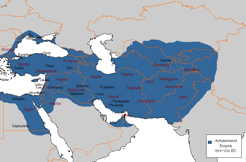
English: Map showing extent of Achaemenid Empire 559 - 330 (BC) |
| Tarix | 27 yanvar 2008 (original upload date); 10 iyul 2010 (original upload date) (last version)) |
| Mənbə |
Öz işi (Original text: self-made based on the following Map) |
| Müəllif |
Arab League. Arab Hafez at ingilis Vikipediya. Later version(s) were uploaded by Beao at ingilis Vikipediya. |
Lisenziya
| This work has been released into the public domain by its author, Arab Hafez at ingilis Vikipediya. This applies worldwide. In some countries this may not be legally possible; if so: Arab Hafez grants anyone the right to use this work for any purpose, without any conditions, unless such conditions are required by law. |
Orijinal yükləmə gündəliyi
Transferred from en.wikipedia to Commons by Quadell using CommonsHelper.
The original description page was here. All following user names refer to en.wikipedia.
- 2010-07-10 20:12 Beao 860×567× (20387 bytes) Removed watermark.
- 2008-01-27 04:22 Arab Hafez 860×567× (21213 bytes) {{Information |Description= |Source=self-made based on the following Map [[Image:Map achaemenid empire en.png]] |Date=27-01-2008 |Location=Central Asia, Middle East, Eastern Europe |Author=[[User:Arab League|Arab League]] |Permission= |other_versions= }}
Orijinal yükləmə gündəliyi
| Tarix/Vaxt | Ölçülər | İstifadəçi | Şərh |
|---|---|---|---|
| 26 iyun 2013, 20:28:32 | 860 × 567 (20387 bytes) | File Upload Bot (Magnus Manske) (müzakirə · töhfələr) | Transfered from en.wikipedia by [[User:Quadell]] using CommonsHelper |
Faylın tarixçəsi
Faylın əvvəlki versiyasını görmək üçün gün/tarix bölməsindəki tarixlərə klikləyin.
| Tarix/Vaxt | Kiçik şəkil | Ölçülər | İstifadəçi | Şərh | |
|---|---|---|---|---|---|
| indiki | 21:30, 10 avqust 2015 | | 860 × 567 (34 KB) | History of Persia | More accurate map. darius conquered the indus valley, darius (or cyrus) conquered arabia, egypt had more territories and exxaduration in central asia was removed. |
| 21:12, 5 avqust 2014 |  | 860 × 567 (22 KB) | GifTagger | Bot: Converting file to superior PNG file. (Source: Achaemenid_Empire_559_-_330_(BC).GIF). This GIF was problematic due to non-greyscale color table. |
.GIF)
Fayl keçidləri
Aşağıdakı 2 səhifə bu faylı istifadə edir:
Faylın qlobal istifadəsi
Bu fayl aşağıdakı vikilərdə istifadə olunur:
- ca.wikipedia.org layihəsində istifadəsi
- en.wikipedia.org layihəsində istifadəsi
- eo.wikipedia.org layihəsində istifadəsi
- fa.wikipedia.org layihəsində istifadəsi
- fr.wikipedia.org layihəsində istifadəsi
- nl.wikipedia.org layihəsində istifadəsi
- uk.wikipedia.org layihəsində istifadəsi
.png)