Fayl:Afghanistan region during 500 BC.jpg
Afghanistan_region_during_500_BC.jpg (348 × 347 piksel, fayl həcmi: 56 KB, MIME növü: image/jpeg)
| Bu fayl "Vikimedia Commons"dadır və digər layihələrdə istifadə edilə bilər. |
 |
Faylın təsvir səhifəsinə get |
| İzah |
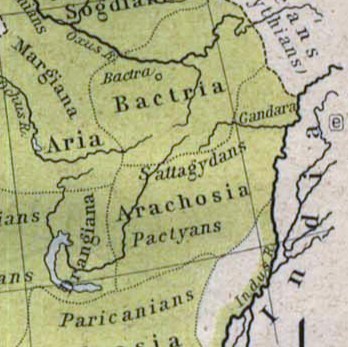
Español: Mapa histórico del Imperio Aqueménida.
English: Historic map of the Achaemenid Empire
Français : Carte historique de l'empire achéménide
Arachosia, Aria and Bactria were the ancient satraps of the Persian Achaemenid Empire that made up most of what is now Afghanistan and western Pakistan during 500 B.C. The main inhabitants of Arachosia were known as Pactyans, whose name possibly survives in today's Pakhtuns. |
||||
| Tarix | |||||
| Mənbə |
http://www.lib.utexas.edu/maps/historical/history_asia.html http://www.lib.utexas.edu/maps/historical/shepherd/persian_empire.jpg |
||||
| Müəllif | William R. Shepherd (b. 1871 - d. 1934) | ||||
| İcazə (Faylın təkrar istifadəsi) |
|
||||
| Digər versiyalar | File:Map of the Achaemenid Empire.jpg (full) | ||||
Faylın tarixçəsi
Faylın əvvəlki versiyasını görmək üçün gün/tarix bölməsindəki tarixlərə klikləyin.
| Tarix/Vaxt | Kiçik şəkil | Ölçülər | İstifadəçi | Şərh | |
|---|---|---|---|---|---|
| indiki | 13:48, 12 mart 2010 | | 348 × 347 (56 KB) | Officer | {{Information |Description={{es|Mapa histórico del imperio Aqueménido.}} {{en|Historic map of the Achaemenid Empire}} {{fr|Carte historique de l'empire achéménide}} |Source=http://www.lib.utexas.edu/maps/historical/history_asia.html http://www.lib.ut |
| 20:47, 21 yanvar 2010 |  | 324 × 357 (63 KB) | Officer | {{Information |Description={{es|Mapa histórico del imperio Aqueménido.}} {{en|Historic map of the Achaemenid Empire}} {{fr|Carte historique de l'empire achéménide}} |Source=http://www.lib.utexas.edu/maps/historical/history_asia.html http://www.lib.ut |
Fayl keçidləri
Aşağıdakı səhifə bu faylı istifadə edir:
Faylın qlobal istifadəsi
Bu fayl aşağıdakı vikilərdə istifadə olunur:
- am.wikipedia.org layihəsində istifadəsi
- ar.wikipedia.org layihəsində istifadəsi
- azb.wikipedia.org layihəsində istifadəsi
- bg.wikipedia.org layihəsində istifadəsi
- bn.wikipedia.org layihəsində istifadəsi
- ca.wikipedia.org layihəsində istifadəsi
- de.wikipedia.org layihəsində istifadəsi
- en.wikipedia.org layihəsində istifadəsi
- eo.wikipedia.org layihəsində istifadəsi
- es.wikipedia.org layihəsində istifadəsi
- he.wikipedia.org layihəsində istifadəsi
- hi.wikipedia.org layihəsində istifadəsi
- hr.wikipedia.org layihəsində istifadəsi
- hy.wikipedia.org layihəsində istifadəsi
- id.wikipedia.org layihəsində istifadəsi
- it.wikipedia.org layihəsində istifadəsi
- ja.wikipedia.org layihəsində istifadəsi
- ka.wikipedia.org layihəsində istifadəsi
- lt.wikipedia.org layihəsində istifadəsi
- mn.wikipedia.org layihəsində istifadəsi
- pt.wikipedia.org layihəsində istifadəsi
- ro.wikipedia.org layihəsində istifadəsi
- ru.wikipedia.org layihəsində istifadəsi
- sh.wikipedia.org layihəsində istifadəsi
- sk.wikipedia.org layihəsində istifadəsi
- sr.wikipedia.org layihəsində istifadəsi
- ta.wikipedia.org layihəsində istifadəsi
- tg.wikipedia.org layihəsində istifadəsi
- uk.wikipedia.org layihəsində istifadəsi
Bu faylın qlobal istifadəsinə baxın.