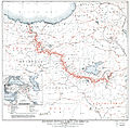
Fayl:Boundary between Turkey and Armenia as determined by Woodrow Wilson.jpg

Faylın orijinalı(8.953 × 8.820 piksel, fayl həcmi: 42,55 MB, MIME növü: image/jpeg)

Bu fayl "Vikimedia Commons"dadır
və digər layihələrdə istifadə edilə bilər.
təsvir səhifəsi
təsvir səhifəsi
Faylın təsvir səhifəsinə get
Warning The original file is very high-resolution. It might not load properly or could cause your browser to freeze when opened at full size.

Xülasə

İzah
English: The western boundary of the proposed Armenian state created by the Treaty of Sèvres.
Tarix
Mənbə http://hdl.loc.gov/loc.gmd/g7431f.ct000197
Müəllif Major Lawrence Martin, General Staff, U.S. Army

File:First_republic_of_Armenia-west_boarders_by_Woodrow_Wilson.png

Lisenziya

Public domain
This image is in the public domain in the United States because it only contains materials that originally came from the United States Geological Survey, an agency of the United States Department of the Interior. For more information, see the official USGS copyright policy.

Bahasa Indonesia  català  čeština  Deutsch  eesti  English  español  français  galego  italiano  Nederlands  português  polski  sicilianu  suomi  Tiếng Việt  Türkçe  български  македонски  русский  മലയാളം  한국어  日本語  中文  中文(简体)  中文(繁體)  العربية  فارسی  +/−

Captions

Sevr müqaviləsi ilə yaradılan təklif edilən Ermənistan dövlətinin qərb sərhədi

Items portrayed in this file

təsvir edir

26 avqust 2012

MIME type ingilis

image/jpeg

checksum ingilis

7c916f7504b1c62086603db137ef20897a4aba5b

data size ingilis

44.621.781 Bayt

8.953 piksel

Faylın tarixçəsi

Faylın əvvəlki versiyasını görmək üçün gün/tarix bölməsindəki tarixlərə klikləyin.

Tarix/VaxtKiçik şəkilÖlçülərİstifadəçiŞərh
indiki03:03, 27 avqust 201203:03, 27 avqust 2012 tarixindəki versiyanın kiçildilmiş görüntüsü8.953 × 8.820 (42,55 MB)ChrisheleniusUser created page with UploadWizard

Aşağıdakı səhifə bu faylı istifadə edir:

Faylın qlobal istifadəsi

Bu fayl aşağıdakı vikilərdə istifadə olunur:

Metaməlumatlar