Fayl:Egg Island, Bahamas ESA391953.jpg

Faylın orijinalı (8.816 × 7.000 piksel, fayl həcmi: 4,35 MB, MIME növü: image/jpeg)
| Bu fayl "Vikimedia Commons"dadır və digər layihələrdə istifadə edilə bilər. |
 |
Faylın təsvir səhifəsinə get |
Xülasə
| İzah |
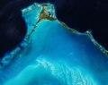
English: When it comes to eggs, most of us are probably thinking of the chocolate variety that we hope will pass our way this weekend, but they’re difficult to spot from space. Instead, we can offer you this gorgeous Copernicus Sentinel-2B picture of Egg Island in the Bahamas.
Covering just 800 sq m, Egg Island is officially an islet. This tiny uninhabited patch is at the northwest end of the long thin chain of islands that form the Eleuthera archipelago, about 70 km from Nassau. Its name perhaps originates from the seabird eggs collected here. The image, which Sentinel-2B captured on 2 February 2018, shows the sharp contrast between the beautiful shallow turquoise waters to the southwest and the deeper darker Atlantic waters to the northeast. Ripples of sand waves created by currents stand out in the shallow waters. These shallow waters are a natural nursery for sea turtles and other sea life. Any disturbance to this delicate ecosystem could spell disaster for wildlife. In fact, Egg Island was recently at risk of being developed as a cruise ship port, which would have meant dredging the seabed and destroying coral reefs. Fortunately, this plan didn't take hold because of the damage it would cause to the environment. This image is also featured on theEarth from Space video programme. |
| Tarix | |
| Mənbə | http://www.esa.int/spaceinimages/Images/2018/03/Egg_Island_Bahamas |
| Müəllif | European Space Agency |
| İcazə (Faylın təkrar istifadəsi) |
contains modified Copernicus Sentinel data (2018), processed by ESA,CC BY-SA 3.0 IGO |
| Digər versiyalar |
|
| Title | Egg Island, Bahamas |
| Set | Earth observation image of the week |
| System | Copernicus |
| Mission | Sentinel-2 |
| Location | Bahamas |
| Activity | Observing the Earth |
| Keywords | Islands |
Lisenziya
- Azadsınız:
- paylaşmaq – əsəri köçürmək, paylamaq və ötürmək üçün
- remiks etmək – əsəri adaptasiya etmək
- Aşağıdakı şərtlərə riayət etməklə:
- istinad – Müvafiq kredit verməlisiniz, lisenziyaya bir keçid verməlisiniz və dəyişikliklərin olub olmadığını bildirməlisiniz. Bunu hər hansı bir ağlabatan şəkildə edə bilərsiniz, ancaq lisenziyalaşdırıcının sizi və ya istifadənizi təsdiqləməsini təklif edən bir şəkildə deyil.
- bənzər paylaşma – Əsəri remix edirsinizsə, dəyişdirirsinizsə və ya üzərində iş aparırsınızsa, öz töhfələrinizi orijinalda olduğu kimi eyni və ya uyğun lisenziya altında yayımlamalısınız.

|
This image contains data from a satellite in the Copernicus Programme, such as Sentinel-1, Sentinel-2 or Sentinel-3. Attribution is required when using this image.
İstinad: Contains modified Copernicus Sentinel data {{{year}}}
The use of Copernicus Sentinel Data is regulated under EU law (Commission Delegated Regulation (EU) No 1159/2013 and Regulation (EU) No 377/2014). Relevant excerpts:
Free access shall be given to GMES dedicated data [...] made available through GMES dissemination platforms [...].
Access to GMES dedicated data [...] shall be given for the purpose of the following use in so far as it is lawful:
GMES dedicated data [...] may be used worldwide without limitations in time.
GMES dedicated data and GMES service information are provided to users without any express or implied warranty, including as regards quality and suitability for any purpose. |
Faylın tarixçəsi
Faylın əvvəlki versiyasını görmək üçün gün/tarix bölməsindəki tarixlərə klikləyin.
| Tarix/Vaxt | Kiçik şəkil | Ölçülər | İstifadəçi | Şərh | |
|---|---|---|---|---|---|
| indiki | 15:56, 30 mart 2018 | | 8.816 × 7.000 (4,35 MB) | Fæ | European Space Agency, Id 391953, http://www.esa.int/spaceinimages/Images/2018/03/Egg_Island_Bahamas, User:Fæ/Project_list/ESA |
Fayl keçidləri
Aşağıdakı səhifə bu faylı istifadə edir:
Faylın qlobal istifadəsi
Bu fayl aşağıdakı vikilərdə istifadə olunur:
- ceb.wikipedia.org layihəsində istifadəsi
- es.wikipedia.org layihəsində istifadəsi
- fr.wikipedia.org layihəsində istifadəsi
- www.wikidata.org layihəsində istifadəsi