Fayl:First Republic of Armenia in 1918-1920.png

Sınaq göstərişi ölçüsü: 799 × 348 piksel. Digər ölçülər: 320 × 139 piksel | 640 × 279 piksel | 1.024 × 446 piksel | 1.280 × 558 piksel | 2.560 × 1.115 piksel | 8.192 × 3.568 piksel.
Faylın orijinalı (8.192 × 3.568 piksel, fayl həcmi: 14,85 MB, MIME növü: image/png)
| Bu fayl "Vikimedia Commons"dadır və digər layihələrdə istifadə edilə bilər. |
 |
Faylın təsvir səhifəsinə get |
Xülasə
| İzah |
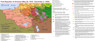
English: The First Republic of Armenia in 1918-1920. |
| Tarix | |
| Mənbə | Öz işi |
| Müəllif | Accipite7 |
Lisenziya
I, the copyright holder of this work, hereby publish it under the following license:
This file is licensed under the Creative Commons Attribution-Share Alike 4.0 International license.
- Azadsınız:
- paylaşmaq – əsəri köçürmək, paylamaq və ötürmək üçün
- remiks etmək – əsəri adaptasiya etmək
- Aşağıdakı şərtlərə riayət etməklə:
- istinad – Müvafiq kredit verməlisiniz, lisenziyaya bir keçid verməlisiniz və dəyişikliklərin olub olmadığını bildirməlisiniz. Bunu hər hansı bir ağlabatan şəkildə edə bilərsiniz, ancaq lisenziyalaşdırıcının sizi və ya istifadənizi təsdiqləməsini təklif edən bir şəkildə deyil.
- bənzər paylaşma – Əsəri remix edirsinizsə, dəyişdirirsinizsə və ya üzərində iş aparırsınızsa, öz töhfələrinizi orijinalda olduğu kimi eyni və ya uyğun lisenziya altında yayımlamalısınız.
Faylın tarixçəsi
Faylın əvvəlki versiyasını görmək üçün gün/tarix bölməsindəki tarixlərə klikləyin.
| Tarix/Vaxt | Miniatür | Ölçülər | İstifadəçi | Şərh | |
|---|---|---|---|---|---|
| hal-hazırkı | 15:13, 2 iyun 2021 | | 8.192 × 3.568 (14,85 MB) | Accipite7 | for the convenience of viewing small details, the size is increased, the colors are improved |
| 08:17, 25 may 2021 |  | 4.096 × 1.784 (3,69 MB) | Accipite7 | The border between Nahang of Shirak and Nahang of Syunik has been clarified. | |
| 09:59, 21 may 2021 |  | 4.096 × 1.784 (3,7 MB) | Accipite7 | The temporary border between the Republic of Armenia and the Soviet republics (August 10, 1920) in the Nakhichevan county has been clarified. Added a legend marked on the map under the number 26. | |
| 08:35, 13 may 2021 |  | 4.096 × 1.784 (3,97 MB) | Accipite7 | fixed typo | |
| 08:27, 13 may 2021 |  | 4.096 × 1.784 (3,97 MB) | Accipite7 | The names of the types of administrative units of the former Russian Empire have been clarified: uyezd = county, okrug = district, oblast = territory, guberniya = governorate. | |
| 11:14, 12 may 2021 |  | 4.096 × 1.784 (3,71 MB) | Accipite7 | Corrected data in the map legend regarding what is indicated on the map by numbers. Clarified the boundaries of the territories required at the Paris Peace Conference. I strongly ask the user of Culminatio not to vandalize and not return the map to the version on which he marked the line reached as a result of the Turkish offensive in 1920. Since, firstly, it is neural: Batumi, Artvin and Ardahan were under the control of the Democratic Republic of Georgia until February-March 1921. And secon... | |
| 04:13, 12 may 2021 |  | 5.375 × 2.341 (7,18 MB) | Culminatio | Reverted to version as of 15:05, 8 May 2021 (UTC) | |
| 07:11, 11 may 2021 |  | 4.096 × 1.784 (3,99 MB) | Accipite7 | The boundaries of the territory of the demands of the Armenian delegation in the Transcaucasus, submitted to the Paris Peace Conference of 1919, were clarified. There is no need to overload the map with the line reached by the Turkish forces in 1920, as the map already shows the results of the Armenian-Turkish war of 1920 - the border according to the Treaty of Alexandropol, December 2, 1920 | |
| 15:05, 8 may 2021 |  | 5.375 × 2.341 (7,18 MB) | Culminatio | Additional line of the turkish advance on the northern positions during the war of 1920. Additional numbers 10,19,20,21 on the map. | |
| 10:49, 8 may 2021 |  | 6.336 × 2.760 (2,21 MB) | Accipite7 | Improved colors. |
Faylın istifadəsi
Aşağıdakı səhifə bu faylı istifadə edir:
Faylın qlobal istifadəsi
Bu fayl aşağıdakı vikilərdə istifadə olunur:
- be.wikipedia.org layihəsində istifadəsi
- bg.wikipedia.org layihəsində istifadəsi
- de.wikipedia.org layihəsində istifadəsi
- el.wikipedia.org layihəsində istifadəsi
- fi.wikipedia.org layihəsində istifadəsi
- fr.wikipedia.org layihəsində istifadəsi
- hy.wikipedia.org layihəsində istifadəsi
- it.wikipedia.org layihəsində istifadəsi
- nl.wikipedia.org layihəsində istifadəsi
- pl.wikipedia.org layihəsində istifadəsi
- pt.wikipedia.org layihəsində istifadəsi
- ro.wikipedia.org layihəsində istifadəsi
- ru.wikipedia.org layihəsində istifadəsi
- sr.wikipedia.org layihəsində istifadəsi
- uk.wikipedia.org layihəsində istifadəsi
- zh.wikipedia.org layihəsində istifadəsi