Fayl:Greece in 1210.svg

Bu SVG-faylın PNG formatındakı bu görünüşünün ölçüsü: 800 × 456 piksel. Digər ölçülər: 320 × 182 piksel | 640 × 365 piksel | 1.024 × 584 piksel | 1.280 × 730 piksel | 2.560 × 1.460 piksel | 3.508 × 2.000 piksel.
Faylın orijinalı (SVG faylı, nominal olaraq 3.508 × 2.000 piksel, faylın ölçüsü: 1,12 MB)
| Bu fayl "Vikimedia Commons"dadır və digər layihələrdə istifadə edilə bilər. |
 |
Faylın təsvir səhifəsinə get |
Xülasə
| İzah |
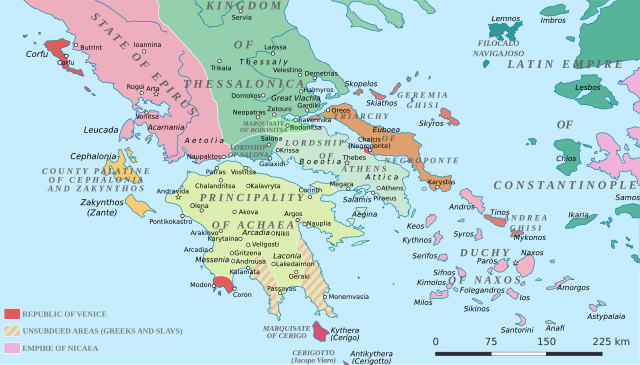
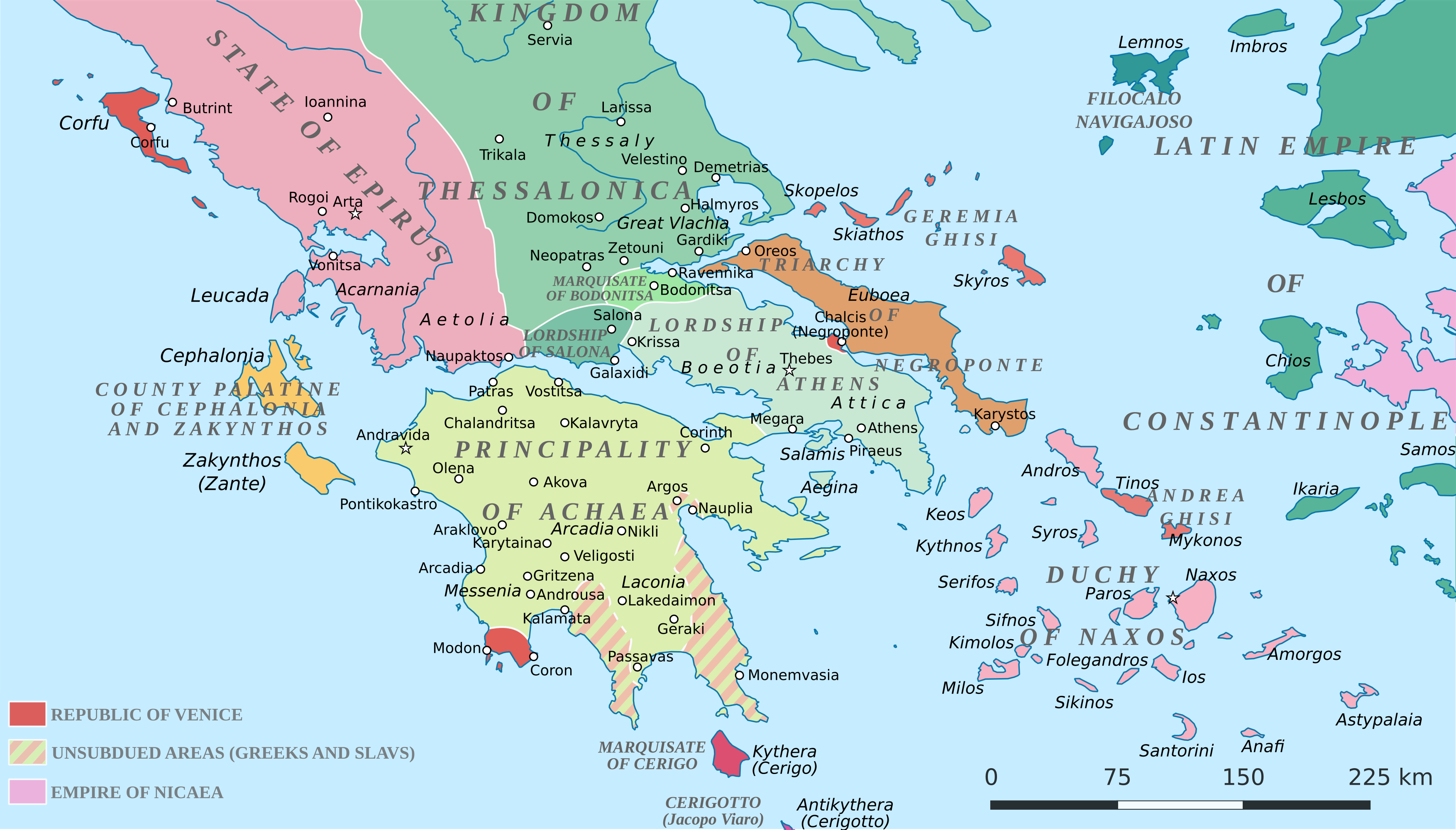
English: Political map of southern Greece in c. 1210, after the establishment of the Crusader states following the Fourth Crusade. |
| Tarix | |
| Mənbə |
SVG base from File:Greece in 1210V1.svg; based on the original political map by William Miller (1908), with changes and corrections to account for newer scholarship:
|
| Müəllif | Cplakidas |
| Digər versiyalar |
|


Lisenziya
I, the copyright holder of this work, hereby publish it under the following license:
This file is licensed under the Creative Commons Attribution-Share Alike 4.0 International license.
- Azadsınız:
- paylaşmaq – əsəri köçürmək, paylamaq və ötürmək üçün
- remiks etmək – əsəri adaptasiya etmək
- Aşağıdakı şərtlərə riayət etməklə:
- istinad – Müvafiq kredit verməlisiniz, lisenziyaya bir keçid verməlisiniz və dəyişikliklərin olub olmadığını bildirməlisiniz. Bunu hər hansı bir ağlabatan şəkildə edə bilərsiniz, ancaq lisenziyalaşdırıcının sizi və ya istifadənizi təsdiqləməsini təklif edən bir şəkildə deyil.
- bənzər paylaşma – Əsəri remix edirsinizsə, dəyişdirirsinizsə və ya üzərində iş aparırsınızsa, öz töhfələrinizi orijinalda olduğu kimi eyni və ya uyğun lisenziya altında yayımlamalısınız.
Faylın tarixçəsi
Faylın əvvəlki versiyasını görmək üçün gün/tarix bölməsindəki tarixlərə klikləyin.
| Tarix/Vaxt | Miniatür | Ölçülər | İstifadəçi | Şərh | |
|---|---|---|---|---|---|
| hal-hazırkı | 19:59, 23 iyun 2017 | | 3.508 × 2.000 (1,12 MB) | Cplakidas | fixed three names to paths |
| 12:08, 11 aprel 2017 |  | 3.508 × 2.000 (1,1 MB) | Cplakidas | colour changes | |
| 11:48, 11 aprel 2017 |  | 3.508 × 2.000 (1,11 MB) | Cplakidas | tweak around Coron | |
| 10:39, 11 fevral 2017 |  | 3.508 × 2.000 (1,11 MB) | Cplakidas | tweaks in Negroponte, unsubdued areas | |
| 17:57, 8 fevral 2017 |  | 3.508 × 2.000 (1,11 MB) | Cplakidas | tweaking the Morea | |
| 13:40, 8 fevral 2017 |  | 3.508 × 2.000 (1,11 MB) | Cplakidas | slight tweaks | |
| 13:14, 8 fevral 2017 |  | 3.508 × 2.000 (1,11 MB) | Cplakidas | User created page with UploadWizard |
Faylın istifadəsi
Aşağıdakı səhifə bu faylı istifadə edir:
Faylın qlobal istifadəsi
Bu fayl aşağıdakı vikilərdə istifadə olunur:
- ar.wikipedia.org layihəsində istifadəsi
- bg.wikipedia.org layihəsində istifadəsi
- ca.wikipedia.org layihəsində istifadəsi
- da.wikipedia.org layihəsində istifadəsi
- de.wikipedia.org layihəsində istifadəsi
- el.wikipedia.org layihəsində istifadəsi
- en.wikipedia.org layihəsində istifadəsi
- eo.wikipedia.org layihəsində istifadəsi
- eu.wikipedia.org layihəsində istifadəsi
- fa.wikipedia.org layihəsində istifadəsi
- fr.wikipedia.org layihəsində istifadəsi
- gl.wikipedia.org layihəsində istifadəsi
- hr.wikipedia.org layihəsində istifadəsi
- id.wikipedia.org layihəsində istifadəsi
- it.wikipedia.org layihəsində istifadəsi
- ja.wikipedia.org layihəsində istifadəsi
- ko.wikipedia.org layihəsində istifadəsi
- ro.wikipedia.org layihəsində istifadəsi
- ru.wikipedia.org layihəsində istifadəsi
- sk.wikipedia.org layihəsində istifadəsi
Bu faylın qlobal istifadəsinə baxın.