Fayl:Map-Germany-1945.svg
Faylın orijinalı(SVG faylı, nominal olaraq 3.492 × 2.966 piksel, faylın ölçüsü: 726 KB)

Bu fayl "Vikimedia Commons"dadır
və digər layihələrdə istifadə edilə bilər.
təsvir səhifəsi
təsvir səhifəsi
Faylın təsvir səhifəsinə get

Xülasə

İzah
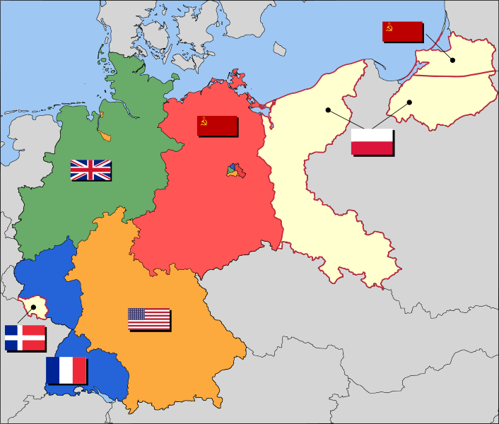
العربية: حدود المناطق المحتلة في ألمانيا عام 1957. الاراضي شرق خط نيس تحت السيطرة البولندية والسوفييتية، تظهر بلون ابيض. برلين منطقة مسيطر عليها من عدة بلدان داخل المنطقة السوفييتة.
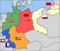
English: Occupation zone borders in Germany, 1947. The territories east of the Oder-Neisse line, under Polish and Soviet administration/annexation, are shown as cream as is the likewise detached Saar protectorate. Berlin is the multinational area within the Soviet zone.
Français : Carte des zones d'occupation de l'Allemagne : le protectorat français de la Sarre apparait en blanc-crème, comme la Silésie, la Poméranie et les autres régions allemandes orientales annexées par la Pologne et l'Union Soviétique.
Deutsch: Grenzen der Besatzungszonen in Deutschland, 1947. Die Gebiete östlich der Oder-Neiße-Grenze, unter polnischer und sowjetischer Verwaltung/Annexion, sowie das Saar-Protektorat sind cremefarben dargestellt. Berlin ist ein multinationales Gebiet inmitten der sowjetischen Besatzungszone.
Tarix 17 mart 2008 (original upload date)
Mənbə Based on map data of the IEG-Maps project (Andreas Kunz, B. Johnen and Joachim Robert Moeschl: University of Mainz) - www.ieg-maps.uni-mainz.de.
Müəllif User:52 Pickup
SVG genesis
InfoField
 
The source code of this SVG is invalid due to 11 errors.
 
This W3C-invalid map was created with Inkscape…important.

Lisenziya

w:az:Creative Commons
istinad bənzər paylaşma
This file is licensed under the Creative Commons Attribution-Share Alike 2.5 Generic license.
Azadsınız:
  • paylaşmaq – əsəri köçürmək, paylamaq və ötürmək üçün
  • remiks etmək – əsəri adaptasiya etmək
Aşağıdakı şərtlərə riayət etməklə:
  • istinad – Müvafiq kredit verməlisiniz, lisenziyaya bir keçid verməlisiniz və dəyişikliklərin olub olmadığını bildirməlisiniz. Bunu hər hansı bir ağlabatan şəkildə edə bilərsiniz, ancaq lisenziyalaşdırıcının sizi və ya istifadənizi təsdiqləməsini təklif edən bir şəkildə deyil.
  • bənzər paylaşma – Əsəri remix edirsinizsə, dəyişdirirsinizsə və ya üzərində iş aparırsınızsa, öz töhfələrinizi orijinalda olduğu kimi eyni və ya uyğun lisenziya altında yayımlamalısınız.

Orijinal yükləmə gündəliyi

Transferred from en.wikipedia to Commons by Broadbeer using CommonsHelper.

The original description page was here. All following user names refer to en.wikipedia.
  • 2008-03-17 19:50 52 Pickup 3492×2966× (760290 bytes) Changes to fill and border colours. Made differences clearer between occupation zones and eventual territorial losses.
  • 2007-08-31 14:57 52 Pickup 3492×2966× (755561 bytes) New version: regions placed under Polish and Soviet administration now presented slightly differently (borders instead of colour fill), Saar colour now only slightly different to French zone (still needs some work)
  • 2007-08-10 09:50 52 Pickup 3492×2966× (751829 bytes) oops, now with fixed image size
  • 2007-08-10 09:47 52 Pickup 744×1052× (751774 bytes) {{Information| |Description= Germany in the aftermath of World War II: 1 September 1945 |Source= Based on map data of the IEG-Maps project (Andreas Kunz, B. Johnen and Joachim Robert Moeschl: University of Mainz) - [http://www.ieg-maps.uni-mainz.de www.ie
Annotations
InfoField
This image is annotated: View the annotations at Commons

Captions

Add a one-line explanation of what this file represents
Occupation map of Germany after WW2

Items portrayed in this file

təsvir edir

copyrighted ingilis

17 mart 2008

У ingilis

Faylın tarixçəsi

Faylın əvvəlki versiyasını görmək üçün gün/tarix bölməsindəki tarixlərə klikləyin.

Tarix/VaxtKiçik şəkilÖlçülərİstifadəçiŞərh
indiki04:37, 1 dekabr 201704:37, 1 dekabr 2017 tarixindəki versiyanın kiçildilmiş görüntüsü3.492 × 2.966 (726 KB)SammimackUpdated flags and colours
14:13, 3 iyul 201514:13, 3 iyul 2015 tarixindəki versiyanın kiçildilmiş görüntüsü3.492 × 2.966 (728 KB)LichaoshengNew 48-Star US Flag from File:US flag 48 stars.svg
14:00, 3 iyul 201514:00, 3 iyul 2015 tarixindəki versiyanın kiçildilmiş görüntüsü3.492 × 2.966 (742 KB)LichaoshengReverted to version as of 18:46, 8 October 2008
15:19, 4 fevral 201215:19, 4 fevral 2012 tarixindəki versiyanın kiçildilmiş görüntüsü3.492 × 2.966 (742 KB)AnonMoosReverted to version as of 18:46, 8 October 2008 -- Kaliningrad had quite different status and fate from that of East Germany proper...
19:44, 20 yanvar 201219:44, 20 yanvar 2012 tarixindəki versiyanın kiçildilmiş görüntüsü3.492 × 2.966 (742 KB)Sammy pomponKaliningrado is occuped by USSR.
18:46, 8 oktyabr 200818:46, 8 oktyabr 2008 tarixindəki versiyanın kiçildilmiş görüntüsü3.492 × 2.966 (742 KB)File Upload Bot (Magnus Manske) {{BotMoveToCommons|en.wikipedia}} {{Information |Description={{en|Occupation zone borders in Germany, 1947. The territories east of the en:Oder-Neisse line, under Polish and Soviet administration/annexation, are shown as white as is the likewise det

Faylın qlobal istifadəsi

Bu fayl aşağıdakı vikilərdə istifadə olunur:

Bu faylın qlobal istifadəsinə baxın.

Metaməlumatlar