Fayl:Map-of-southeast-asia 1400 CE.png
Sınaq göstərişi ölçüsü: 426 × 600 piksel. Digər ölçülər: 170 × 240 piksel | 341 × 480 piksel | 791 × 1.114 piksel.
Faylın orijinalı (791 × 1.114 piksel, fayl həcmi: 190 KB, MIME növü: image/png)
| Bu fayl "Vikimedia Commons"dadır və digər layihələrdə istifadə edilə bilər. |
 |
Faylın təsvir səhifəsinə get |

|
This historical map image could be re-created using vector graphics as an SVG file. This has several advantages; see Commons:Media for cleanup for more information. If an SVG form of this image is available, please upload it and afterwards replace this template with
{{vector version available|new image name}}.
It is recommended to name the SVG file “Map-of-southeast-asia 1400 CE.svg”—then the template Vector version available (or Vva) does not need the new image name parameter. |
Xülasə
| İzah |
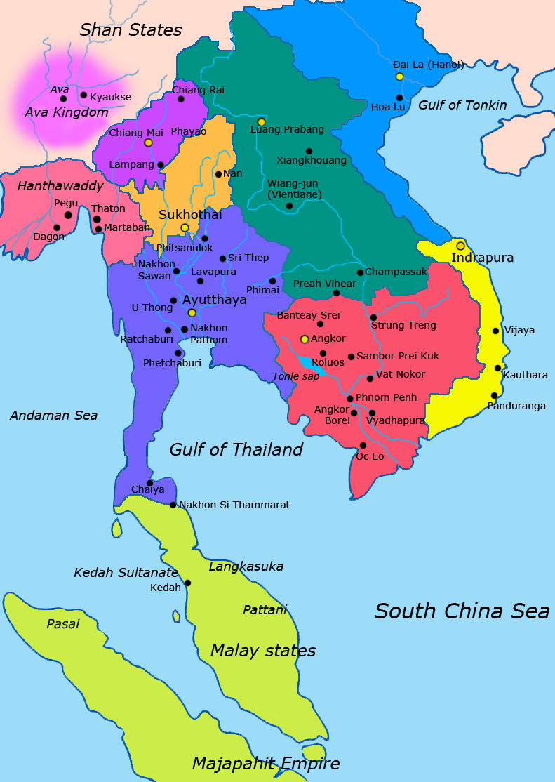
English: Map of Southeast Asia circa 1400 CE, showing Khmer Empire in red, Ayutthaya Kingdom in violet, Lan Xang kingdom in teal, Sukhothai kingdom in orange, Champa in yellow, Kingdom of Lanna in purple, Dai Viet in blue and surrounding states. |
| Tarix | |
| Mənbə |
http://ecaimaps.berkeley.edu/animations/2003_03_khmer_animation.swf http://www.britannica.com/EBchecked/media/3395/Khmer-empire-1200 Atlas of world history, Patrick Karl O'brien. Societies, Networks, and Transitions: A Global History, Volume B. Craig A.Lockard http://upload.wikimedia.org/wikipedia/commons/thumb/4/45/Srivijaya_Empire.svg/2000px-Srivijaya_Empire.svg.png File:DvaravatiMapThailand.png http://upload.wikimedia.org/wikipedia/commons/e/eb/Thailand_2002_CIA_map.jpg |
| Müəllif | Javierfv1212 |
Lisenziya
I, the copyright holder of this work, hereby publish it under the following license:
| This file is made available under the Creative Commons CC0 1.0 Universal Public Domain Dedication. | |
| The person who associated a work with this deed has dedicated the work to the public domain by waiving all of their rights to the work worldwide under copyright law, including all related and neighboring rights, to the extent allowed by law. You can copy, modify, distribute and perform the work, even for commercial purposes, all without asking permission.
|
Faylın tarixçəsi
Faylın əvvəlki versiyasını görmək üçün gün/tarix bölməsindəki tarixlərə klikləyin.
| Tarix/Vaxt | Kiçik şəkil | Ölçülər | İstifadəçi | Şərh | |
|---|---|---|---|---|---|
| indiki | 22:54, 25 yanvar 2022 | | 791 × 1.114 (190 KB) | Yourlocallordandsavior | Reverted to version as of 17:40, 7 March 2021 (UTC) Inaccurate. |
| 08:44, 22 aprel 2021 |  | 1.080 × 1.521 (643 KB) | Monaonh | Map-of-southeast-asia_1400_CE.png | |
| 17:40, 7 mart 2021 |  | 791 × 1.114 (190 KB) | Monaonh | Reverted to version as of 17:26, 7 March 2021 (UTC) | |
| 17:34, 7 mart 2021 |  | 1.080 × 1.521 (643 KB) | Monaonh | File:Map-of-southeast-asia_1400_CE.png | |
| 17:26, 7 mart 2021 |  | 791 × 1.114 (190 KB) | Monaonh | Reverted to version as of 22:51, 19 July 2011 (UTC) | |
| 16:29, 6 mart 2021 |  | 1.080 × 1.521 (643 KB) | Monaonh | File:Map-of-southeast-asia_1400_CE.png | |
| 22:51, 19 iyul 2011 |  | 791 × 1.114 (190 KB) | Ras67 | cropped | |
| 02:31, 28 mart 2011 |  | 800 × 1.125 (256 KB) | Javierfv1212 | {{Information |Description ={{en|1=Map of Southeast Asia circa 1300 CE, showing Khmer Empire in red, Ayutthaya Kingdom in violet, Lan Xang kingdom in teal, Sukhothai kingdom in orange, Champa in yellow, Kingdom of Lanna in purple, Dai Viet in blue and |
Fayl keçidləri
Aşağıdakı səhifə bu faylı istifadə edir:
Faylın qlobal istifadəsi
Bu fayl aşağıdakı vikilərdə istifadə olunur:
- ar.wikipedia.org layihəsində istifadəsi
- ast.wikipedia.org layihəsində istifadəsi
- azb.wikipedia.org layihəsində istifadəsi
- ba.wikipedia.org layihəsində istifadəsi
- br.wikipedia.org layihəsində istifadəsi
- ca.wikipedia.org layihəsində istifadəsi
- cs.wikipedia.org layihəsində istifadəsi
- de.wikipedia.org layihəsində istifadəsi
- en.wikipedia.org layihəsində istifadəsi
- eo.wikipedia.org layihəsində istifadəsi
- es.wikipedia.org layihəsində istifadəsi
- eu.wikipedia.org layihəsində istifadəsi
- fa.wikipedia.org layihəsində istifadəsi
- fi.wikipedia.org layihəsində istifadəsi
- fr.wikipedia.org layihəsində istifadəsi
- hi.wikipedia.org layihəsində istifadəsi
- hr.wikipedia.org layihəsində istifadəsi
- id.wikipedia.org layihəsində istifadəsi
- it.wikipedia.org layihəsində istifadəsi
- ja.wikipedia.org layihəsində istifadəsi
Bu faylın qlobal istifadəsinə baxın.