Fayl:Map of each state's population as of 2013.svg

Bu SVG-faylın PNG formatındakı bu görünüşünün ölçüsü: 800 × 495 piksel. Digər ölçülər: 320 × 198 piksel | 640 × 396 piksel | 1.024 × 633 piksel | 1.280 × 791 piksel | 2.560 × 1.583 piksel | 959 × 593 piksel.
Faylın orijinalı (SVG faylı, nominal olaraq 959 × 593 piksel, faylın ölçüsü: 49 KB)
| Bu fayl "Vikimedia Commons"dadır və digər layihələrdə istifadə edilə bilər. |
 |
Faylın təsvir səhifəsinə get |
Xülasə
| İzah |
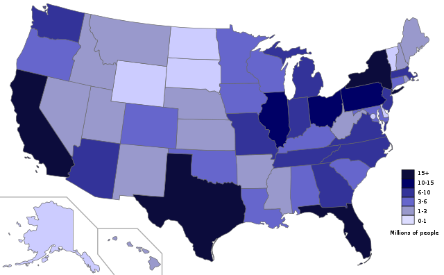
English: The population of the States as of July 2013, based on data from United States Census Bureau. |
| Tarix | |
| Mənbə | Öz işi; Map is based on here. |
| Müəllif | Ali Zifan |
Lisenziya
I, the copyright holder of this work, hereby publish it under the following license:
| This file is made available under the Creative Commons CC0 1.0 Universal Public Domain Dedication. | |
| The person who associated a work with this deed has dedicated the work to the public domain by waiving all of their rights to the work worldwide under copyright law, including all related and neighboring rights, to the extent allowed by law. You can copy, modify, distribute and perform the work, even for commercial purposes, all without asking permission.
|
Faylın tarixçəsi
Faylın əvvəlki versiyasını görmək üçün gün/tarix bölməsindəki tarixlərə klikləyin.
| Tarix/Vaxt | Kiçik şəkil | Ölçülər | İstifadəçi | Şərh | |
|---|---|---|---|---|---|
| indiki | 23:49, 7 dekabr 2014 | | 959 × 593 (49 KB) | Oganesson007 | Updated. |
| 02:16, 25 noyabr 2014 |  | 959 × 593 (49 KB) | Oganesson007 | User created page with UploadWizard |
Fayl keçidləri
Bu faylı istifadə edən səhifə yoxdur.
Faylın qlobal istifadəsi
Bu fayl aşağıdakı vikilərdə istifadə olunur:
- ar.wikipedia.org layihəsində istifadəsi
- ast.wikipedia.org layihəsində istifadəsi
- bg.wikipedia.org layihəsində istifadəsi
- cs.wikipedia.org layihəsində istifadəsi
- de.wikipedia.org layihəsində istifadəsi
- en.wikipedia.org layihəsində istifadəsi
- fa.wikipedia.org layihəsində istifadəsi
- ga.wikipedia.org layihəsində istifadəsi
- hu.wikipedia.org layihəsində istifadəsi
- ilo.wikipedia.org layihəsində istifadəsi
- jv.wikipedia.org layihəsində istifadəsi
- la.wikipedia.org layihəsində istifadəsi
- mk.wikipedia.org layihəsində istifadəsi
- nl.wikipedia.org layihəsində istifadəsi
- pnb.wikipedia.org layihəsində istifadəsi
- ro.wikipedia.org layihəsində istifadəsi
- sco.wikipedia.org layihəsində istifadəsi
- sh.wikipedia.org layihəsində istifadəsi
- simple.wikipedia.org layihəsində istifadəsi
- sk.wikipedia.org layihəsində istifadəsi
- sv.wikipedia.org layihəsində istifadəsi
- th.wikipedia.org layihəsində istifadəsi
- ur.wikipedia.org layihəsində istifadəsi
- vi.wikipedia.org layihəsində istifadəsi
- xmf.wikipedia.org layihəsində istifadəsi