Fayl:Mount Bulka.jpg

Sınaq göstərişi ölçüsü: 800 × 450 piksel. Digər ölçülər: 320 × 180 piksel | 640 × 360 piksel | 1.024 × 576 piksel | 1.280 × 720 piksel | 3.072 × 1.728 piksel.
Faylın orijinalı (3.072 × 1.728 piksel, fayl həcmi: 690 KB, MIME növü: image/jpeg)
| Bu fayl "Vikimedia Commons"dadır və digər layihələrdə istifadə edilə bilər. |
 |
Faylın təsvir səhifəsinə get |
Xülasə
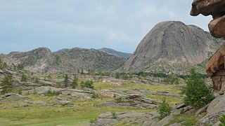
| İzah | Landscape of Bayanaul with mount Bulka (Loaf) on the right known for six lakes located at the top of it |
| Tarix | |
| Mənbə | Öz işi |
| Müəllif | Ekamaloff |
| Camera location | | View this and other nearby images on: OpenStreetMap |
|---|
Lisenziya
| This work has been released into the public domain by its author, I, Ekamaloff. This applies worldwide. In some countries this may not be legally possible; if so: I, Ekamaloff grants anyone the right to use this work for any purpose, without any conditions, unless such conditions are required by law. |
Faylın tarixçəsi
Faylın əvvəlki versiyasını görmək üçün gün/tarix bölməsindəki tarixlərə klikləyin.
| Tarix/Vaxt | Kiçik şəkil | Ölçülər | İstifadəçi | Şərh | |
|---|---|---|---|---|---|
| indiki | 17:59, 18 iyul 2007 | | 3.072 × 1.728 (690 KB) | Ekamaloff | {{Information |Description=Mount Bulka (Loaf) |Source=self-made |Date=July 13 2007 |Author= Ekamaloff }} {{Location|50|48|51.4|N|75|33|12.7|E}} Category:Images by Ekamaloff Category:Bayanaul |
Fayl keçidləri
Aşağıdakı 2 səhifə bu faylı istifadə edir:
Faylın qlobal istifadəsi
Bu fayl aşağıdakı vikilərdə istifadə olunur:
- bg.wikipedia.org layihəsində istifadəsi
- en.wikipedia.org layihəsində istifadəsi
- en.wikivoyage.org layihəsində istifadəsi
- es.wikipedia.org layihəsində istifadəsi
- fa.wikipedia.org layihəsində istifadəsi
- fr.wikipedia.org layihəsində istifadəsi
- fr.wikivoyage.org layihəsində istifadəsi
- hu.wikipedia.org layihəsində istifadəsi
- it.wikipedia.org layihəsində istifadəsi
- kk.wikipedia.org layihəsində istifadəsi
- pl.wikipedia.org layihəsində istifadəsi
- ru.wikipedia.org layihəsində istifadəsi
- ru.wikivoyage.org layihəsində istifadəsi
- sl.wikipedia.org layihəsində istifadəsi
- tr.wikipedia.org layihəsində istifadəsi
- uk.wikipedia.org layihəsində istifadəsi
- www.wikidata.org layihəsində istifadəsi
- zh.wikipedia.org layihəsində istifadəsi
- zh.wikivoyage.org layihəsində istifadəsi