Fayl:New York state geographic map-en.svg

Bu SVG-faylın PNG formatındakı bu görünüşünün ölçüsü: 800 × 569 piksel. Digər ölçülər: 320 × 228 piksel | 640 × 455 piksel | 1.024 × 729 piksel | 1.280 × 911 piksel | 2.560 × 1.821 piksel | 2.811 × 2.000 piksel.
Faylın orijinalı (SVG faylı, nominal olaraq 2.811 × 2.000 piksel, faylın ölçüsü: 18,34 MB)
| Bu fayl "Vikimedia Commons"dadır və digər layihələrdə istifadə edilə bilər. |
 |
Faylın təsvir səhifəsinə get |
Xülasə
| Description |
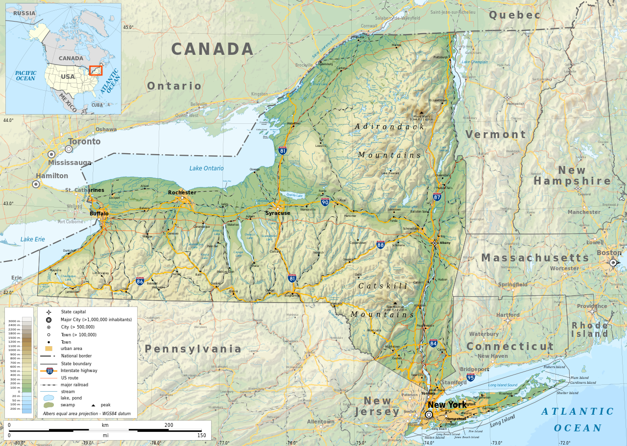
English: Geographic map of New York state in English. Geographic limits of the map:
|
| Tarix | |
| Mənbə |
Öz işi
|
| Yaradıcı | |
| İcazə (Faylın təkrar istifadəsi) |
Any use of this map is subject of the license(s) stated below with the condition that you credit (Wikimedia Commons user: Ikonact) as the author . A message with a reply address would also be greatly appreciated. |
| Georeferencing | If inappropriate please set warp_status = skip to hide. |
|

|
This SVG file contains embedded text that can be translated into your language, using any capable SVG editor, text editor or the SVG Translate tool. For more information see: About translating SVG files. |
Lisenziya
| This work contains information from OpenStreetMap, which is made available under the Open Database License (ODbL).
The ODbL does not require any particular license for maps produced from ODbL data. Prior to 1 August 2020, map tiles produced by the OpenStreetMap Foundation were licensed under the CC-BY-SA-2.0 license. Maps produced by other people may be subject to other licences. |
I, the copyright holder of this work, hereby publish it under the following license:
This file is licensed under the Creative Commons Attribution-Share Alike 4.0 International license.
- Azadsınız:
- paylaşmaq – əsəri köçürmək, paylamaq və ötürmək üçün
- remiks etmək – əsəri adaptasiya etmək
- Aşağıdakı şərtlərə riayət etməklə:
- istinad – Müvafiq kredit verməlisiniz, lisenziyaya bir keçid verməlisiniz və dəyişikliklərin olub olmadığını bildirməlisiniz. Bunu hər hansı bir ağlabatan şəkildə edə bilərsiniz, ancaq lisenziyalaşdırıcının sizi və ya istifadənizi təsdiqləməsini təklif edən bir şəkildə deyil.
- bənzər paylaşma – Əsəri remix edirsinizsə, dəyişdirirsinizsə və ya üzərində iş aparırsınızsa, öz töhfələrinizi orijinalda olduğu kimi eyni və ya uyğun lisenziya altında yayımlamalısınız.
Faylın tarixçəsi
Faylın əvvəlki versiyasını görmək üçün gün/tarix bölməsindəki tarixlərə klikləyin.
| Tarix/Vaxt | Kiçik şəkil | Ölçülər | İstifadəçi | Şərh | |
|---|---|---|---|---|---|
| indiki | 12:15, 2 noyabr 2023 | | 2.811 × 2.000 (18,34 MB) | Ikonact | corrected some typos in names // Editing SVG source code using c:User:Rillke/SVGedit.js |
| 10:22, 14 oktyabr 2019 |  | 2.811 × 2.000 (18,41 MB) | Ikonact | better dealing with fall back font | |
| 21:19, 12 oktyabr 2019 |  | 2.811 × 2.000 (20,53 MB) | Ikonact | + fall back font, more towns and islands, provinces | |
| 23:33, 11 oktyabr 2019 |  | 2.811 × 2.000 (20,47 MB) | Ikonact | error corrected | |
| 23:23, 11 oktyabr 2019 |  | 2.811 × 2.000 (20,47 MB) | Ikonact | river and lake names added | |
| 21:58, 8 oktyabr 2019 |  | 2.811 × 2.000 (20,33 MB) | Ikonact | some improvements, roads and cities in Canada | |
| 07:40, 22 sentyabr 2019 |  | 2.811 × 2.000 (14,39 MB) | Ikonact | small corrections | |
| 20:49, 21 sentyabr 2019 |  | 2.811 × 2.000 (14,39 MB) | Ikonact | + road names | |
| 20:23, 21 sentyabr 2019 |  | 2.811 × 2.000 (14,31 MB) | Ikonact | +names | |
| 22:01, 20 sentyabr 2019 |  | 2.811 × 2.000 (15,37 MB) | Ikonact | == {{int:filedesc}} == {{Information |description={{en|1=Geographic map of New York state in English. Geographic limits of the map:}} *N: 45.30° N *S: 40.30° N *W: 80.20° W *E: 71.00° W Albers equal area projection; WGS 84 datum |date=2019-09-21 |source={{own}} *Sources of data:<br/> **Topography: ETOPO1 (public domain);<br/> **Public domain data provided by the National Atlas of the United States of America;<br/> *Tool:<br/> **The map is created with Octave scripts d... |
Fayl keçidləri
Aşağıdakı səhifə bu faylı istifadə edir:
Faylın qlobal istifadəsi
Bu fayl aşağıdakı vikilərdə istifadə olunur:
- af.wikipedia.org layihəsində istifadəsi
- ang.wikipedia.org layihəsində istifadəsi
- be.wikipedia.org layihəsində istifadəsi
- bg.wikipedia.org layihəsində istifadəsi
- bn.wikipedia.org layihəsində istifadəsi
- ca.wikipedia.org layihəsində istifadəsi
- en.wikipedia.org layihəsində istifadəsi
- eo.wikipedia.org layihəsində istifadəsi
- fr.wikipedia.org layihəsində istifadəsi
- ga.wikipedia.org layihəsində istifadəsi
- gl.wikipedia.org layihəsində istifadəsi
- ha.wikipedia.org layihəsində istifadəsi
- hu.wikipedia.org layihəsində istifadəsi
- hy.wikipedia.org layihəsində istifadəsi
- id.wikipedia.org layihəsində istifadəsi
- lt.wikipedia.org layihəsində istifadəsi
- mhr.wikipedia.org layihəsində istifadəsi
- ml.wikipedia.org layihəsində istifadəsi
- os.wikipedia.org layihəsində istifadəsi
- pcd.wikipedia.org layihəsində istifadəsi
- pl.wikipedia.org layihəsində istifadəsi
- sh.wikipedia.org layihəsində istifadəsi
- tg.wikipedia.org layihəsində istifadəsi
- tr.wikipedia.org layihəsində istifadəsi
- tt.wikipedia.org layihəsində istifadəsi
- uk.wikipedia.org layihəsində istifadəsi
- www.wikidata.org layihəsində istifadəsi