Fayl:Plan de Madras pris par les Francais en 1746.jpg

Sınaq göstərişi ölçüsü: 800 × 521 piksel. Digər ölçülər: 320 × 208 piksel | 640 × 417 piksel | 1.140 × 742 piksel.
Faylın orijinalı (1.140 × 742 piksel, fayl həcmi: 255 KB, MIME növü: image/jpeg)
| Bu fayl "Vikimedia Commons"dadır və digər layihələrdə istifadə edilə bilər. |
 |
Faylın təsvir səhifəsinə get |
Xülasə
| Müəllif |
Sr Paradis |
| İzah |
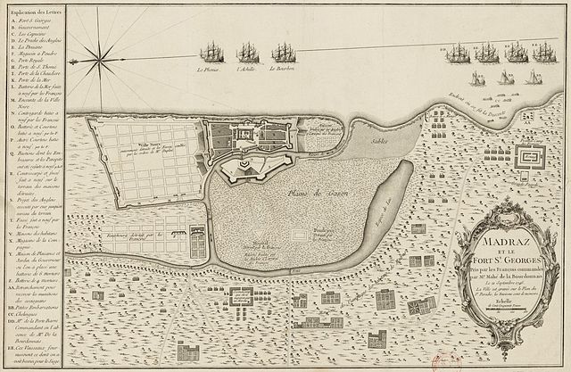
English: Plan of the siege of Madras by La Bourdonnais in 1746, with details of the fortifications and the French ships that participated in the landing. Français : Madraz et le Fort St. Georges pris par les François commandés par Mr. Mahé de la Bourdonnais, le 21 septembre 1746 / la ville est gravée sur le plan du Sr. Paradis. Plan du comptoir anglais dressé après la prise de celui-ci par les navires et les troupes de La Bourdonnais. |
| Depicted place | Chennai (Tamil Nādu, India) 13°05'16"N 80°16'42"E |
| Tarix | 1746 |
| Source/Photographer |
Bibliothèque nationale de France |
| Digər versiyalar |
|

Lisenziya
|
This work is in the public domain in its country of origin and other countries and areas where the copyright term is the author's life plus 100 years or fewer. | |
| This file has been identified as being free of known restrictions under copyright law, including all related and neighboring rights. | |
Faylın tarixçəsi
Faylın əvvəlki versiyasını görmək üçün gün/tarix bölməsindəki tarixlərə klikləyin.
| Tarix/Vaxt | Kiçik şəkil | Ölçülər | İstifadəçi | Şərh | |
|---|---|---|---|---|---|
| indiki | 20:07, 31 oktyabr 2011 | | 1.140 × 742 (255 KB) | AYE R |
Fayl keçidləri
Aşağıdakı səhifə bu faylı istifadə edir:
Faylın qlobal istifadəsi
Bu fayl aşağıdakı vikilərdə istifadə olunur:
- en.wikipedia.org layihəsində istifadəsi
- ml.wikipedia.org layihəsində istifadəsi
- ru.wikipedia.org layihəsində istifadəsi
- sl.wikipedia.org layihəsində istifadəsi
- tr.wikipedia.org layihəsində istifadəsi