Fayl:Population density of Ireland map2002.svg

Bu SVG-faylın PNG formatındakı bu görünüşünün ölçüsü: 480 × 600 piksel. Digər ölçülər: 192 × 240 piksel | 384 × 480 piksel | 614 × 768 piksel | 819 × 1.024 piksel | 1.638 × 2.048 piksel.
Faylın orijinalı (SVG faylı, nominal olaraq 800 × 1.000 piksel, faylın ölçüsü: 621 KB)
| Bu fayl "Vikimedia Commons"dadır və digər layihələrdə istifadə edilə bilər. |
 |
Faylın təsvir səhifəsinə get |
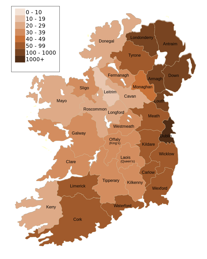
| İzah | Map of Ireland's population density (people per km2). Based upon Republic of Ireland - 2002 Census results. |
| Tarix | (UTC) |
| Mənbə | |
| Müəllif |
|
| Digər versiyalar | Derivative works of this file: Population density of Ireland map2002 RU.svg |
| Bu təsvirin redaktəsi, orijinala əsaslanaraq rəqəmsal qaydadadır. Dəyişiklik: Map of Ireland's population density (people per km2). Based upon Republic of Ireland - 2002 Census results.. İlkin təsvir buradadır: Ireland complete.svg. Redaktə etdi The Illusional Ministry.
|
I, the copyright holder of this work, hereby publish it under the following license:
| Mən, bu əsərin müəllif hüquqlarının sahibi kimi, əsəri ictimai mülkiyyətə verirəm. Bu icazə bütün dünyada qüvvədədir. In some countries this may not be legally possible; if so: Bunun qanunla mümkün olmadığı hallarda: İstənilən şəxsə, istənilən məqsəd üçün, qanunlar tərəfindən qadağan edilməyincə, heç bir şərt qoymadan bu işdən istifadə haqqını bağışlayıram. |
Orijinal yükləmə gündəliyi
This image is a derivative work of the following images:
- File:Ireland_complete.svg licensed with PD-self
- 2007-06-23T17:06:44Z Future Perfect at Sunrise 800x1000 (594536 Bytes) {{Information |Description= |Source=self-made |Date= |Author= [[User:Future Perfect at Sunrise|Future Perfect at Sunrise]] }}
- 2007-06-23T16:45:52Z Future Perfect at Sunrise 800x1000 (590003 Bytes) {{Information |Description= |Source=self-made |Date= |Author= [[User:Future Perfect at Sunrise|Future Perfect at Sunrise]] }}
- 2007-06-23T16:35:48Z Future Perfect at Sunrise 2000x2500 (606764 Bytes) {{Information |Description=SVG map of Ireland. |Source=self-made |Date=23 June 2007 |Author= [[User:Future Perfect at Sunrise|Future Perfect at Sunrise]] }} Note: the SVG code contains separate levels showing boundaries and
Uploaded with derivativeFX
Faylın tarixçəsi
Faylın əvvəlki versiyasını görmək üçün gün/tarix bölməsindəki tarixlərə klikləyin.
| Tarix/Vaxt | Miniatür | Ölçülər | İstifadəçi | Şərh | |
|---|---|---|---|---|---|
| hal-hazırkı | 14:30, 17 oktyabr 2009 | | 800 × 1.000 (621 KB) | The Illusional Ministry | Dublin now in black text |
| 14:27, 17 oktyabr 2009 |  | 800 × 1.000 (621 KB) | The Illusional Ministry | {{Information |Description=Map of Ireland's population density (people per km2). Based upon Republic of Ireland - 2002 Census results. |Source=*File:Ireland_complete.svg |Date=2009-10-17 14:25 (UTC) |Author=*File:Ireland_complete.svg: '''Futur |
Faylın istifadəsi
Bu faylı istifadə edən səhifə yoxdur.
Faylın qlobal istifadəsi
Bu fayl aşağıdakı vikilərdə istifadə olunur:
- de.wikipedia.org layihəsində istifadəsi
- gv.wikipedia.org layihəsində istifadəsi
- he.wikipedia.org layihəsində istifadəsi
- hu.wikipedia.org layihəsində istifadəsi
- kn.wikipedia.org layihəsində istifadəsi
- sd.wikipedia.org layihəsində istifadəsi
- te.wikipedia.org layihəsində istifadəsi