Fayl:ROC PRC comparison eng.jpg

ROC_PRC_comparison_eng.jpg(770 × 600 piksel, fayl həcmi: 239 KB, MIME növü: image/jpeg)

Bu fayl "Vikimedia Commons"dadır
və digər layihələrdə istifadə edilə bilər.
təsvir səhifəsi
təsvir səhifəsi
Faylın təsvir səhifəsinə get
File:ROC vs PRC.svg is a vector version of this file. It should be used in place of this JPG file when not inferior.

File:ROC PRC comparison eng.jpg → File:ROC vs PRC.svg

For more information, see Help:SVG.

In other languages
Alemannisch  Bahasa Indonesia  Bahasa Melayu  British English  català  čeština  dansk  Deutsch  eesti  English  español  Esperanto  euskara  français  Frysk  galego  hrvatski  Ido  italiano  lietuvių  magyar  Nederlands  norsk bokmål  norsk nynorsk  occitan  Plattdüütsch  polski  português  português do Brasil  română  Scots  sicilianu  slovenčina  slovenščina  suomi  svenska  Tiếng Việt  Türkçe  vèneto  Ελληνικά  беларуская (тарашкевіца)  български  македонски  нохчийн  русский  српски / srpski  татарча/tatarça  українська  ქართული  հայերեն  বাংলা  தமிழ்  മലയാളം  ไทย  한국어  日本語  简体中文  繁體中文  עברית  العربية  فارسی  +/−
New SVG image

Atlas This map has been uploaded by Electionworld from en.wikipedia.org to enable the Wikimedia Atlas of the World . Original uploader to en.wikipedia.org was Pryaltonian, known as Pryaltonian at en.wikipedia.org. Electionworld is not the creator of this map. Licensing information is below.

Xülasə

İzah
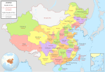
English: Comparison between Republic of China and People's Republic of China administrative divisions.
Legend details
  • Black dotted lines are political boundaries drawn by the ROC. The formal names of these political entities are in black
  • White areas represent the territories claimed by the ROC but not the PRC.
  • The names and the boundary of "South China Sea" is self-claimed by China, which has no valid supported document. Therefore, It is remain a false information and should not be visible anywhere to prevent miseducation.
Origin

Adapted into English by Pryaltonian from the Chinese Wikipedia. The original ROC map included more cities, but the adaptation removed non-central municipalities to clean up the image. Therefore, this image contains:

Republic of China

  • 35 provinces
  • 14 municipalities
  • 2 areas
  • 1 special administrative region

People's Republic of China

  • 23 provinces
  • 4 municipalities
  • 5 autonomous regions
  • 2 special administrative regions

The image also includes the addition of Chongqing as a municipality and the Gansu-Qinghai border change.

Comments, suggestions, adaptations, critiques are all welcome.
Tarix
Mənbə Öz işi
Müəllif Electionworld

Lisenziya

GNU head Bu sənədi GNU Azad Sənədləşdirmə Lisenziyası, Versiya 1.2 və ya Azad Proqram Fondu tərəfindən nəşr olunan hər hansı sonrakı versiya şərtlərinə əsasən dəyişməz bölmələr, ön qapaq mətnləri və arxa qapaq mətnləri olmadan köçürmək, yayımlamaq və / və ya dəyişdirmək üçün icazə verilir; Lisenziyanın bir nüsxəsi GNU Azad Sənədləşdirmə Lisenziyası adlı hissəyə daxil edilmişdir.
w:az:Creative Commons
istinad bənzər paylaşma
Bu fayl Creative Commons Attribution-Share Alike 3.0 Unported lisenziyası altında yayımlanır.
Azadsınız:
  • paylaşmaq – əsəri köçürmək, paylamaq və ötürmək üçün
  • remiks etmək – əsəri adaptasiya etmək
Aşağıdakı şərtlərə riayət etməklə:
  • istinad – Müvafiq kredit verməlisiniz, lisenziyaya bir keçid verməlisiniz və dəyişikliklərin olub olmadığını bildirməlisiniz. Bunu hər hansı bir ağlabatan şəkildə edə bilərsiniz, ancaq lisenziyalaşdırıcının sizi və ya istifadənizi təsdiqləməsini təklif edən bir şəkildə deyil.
  • bənzər paylaşma – Əsəri remix edirsinizsə, dəyişdirirsinizsə və ya üzərində iş aparırsınızsa, öz töhfələrinizi orijinalda olduğu kimi eyni və ya uyğun lisenziya altında yayımlamalısınız.
This licensing tag was added to this file as part of the GFDL licensing update.

GNU was used on the Chinese page, so same copyright information should apply. -Pryaltonian 04:45, 3 September 2006 (UTC)

Captions

Add a one-line explanation of what this file represents

Items portrayed in this file

təsvir edir

copyrighted ingilis

3 iyul 2006

MIME type ingilis

image/jpeg

Faylın tarixçəsi

Faylın əvvəlki versiyasını görmək üçün gün/tarix bölməsindəki tarixlərə klikləyin.

Tarix/VaxtKiçik şəkilÖlçülərİstifadəçiŞərh
indiki19:48, 18 yanvar 201519:48, 18 yanvar 2015 tarixindəki versiyanın kiçildilmiş görüntüsü770 × 600 (239 KB)WwbreadPart of Bhutan and Russia was Rep. China. It has been marked in this map but not painted white. Also marked Nanking and Peking by two bigger stars.
14:03, 16 dekabr 200614:03, 16 dekabr 2006 tarixindəki versiyanın kiçildilmiş görüntüsü770 × 600 (316 KB)Electionworld{{ew|en|Pryaltonian}} == Legend details == * Black dotted lines are political boundaries drawn by the ROC. The formal names of these political entities are in black text. * Red solid lines are political boundaries drawn by the [[P

Aşağıdakı səhifə bu faylı istifadə edir:

Faylın qlobal istifadəsi

Bu fayl aşağıdakı vikilərdə istifadə olunur:

Bu faylın qlobal istifadəsinə baxın.