Fayl:Spitsbergen labelled.png
Spitsbergen_labelled.png (451 × 446 piksel, fayl həcmi: 161 KB, MIME növü: image/png)
| Bu fayl "Vikimedia Commons"dadır və digər layihələrdə istifadə edilə bilər. |
 |
Faylın təsvir səhifəsinə get |
Xülasə
| İzah |
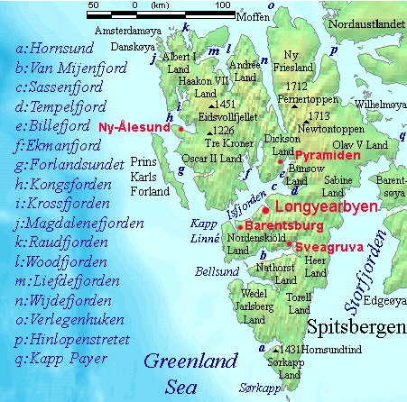
English: Map detailing the marine features of Spitsbergen in the Svalbard archipelago. Settlements and mountains are indicated and labelled. See also Image:Spitsbergen mountains and marine features labelled.png. Locations were labelled mainly based on detailed maps from svalbard-images.com (sample of south Spitsbergen linked), cross-referenced with other map sources where possible. Norwegian Polar Institute figures were used for mountain names and heights, which are given in meters above sea level. |
| Tarix | 25 iyul 2006 (original upload date) |
| Mənbə | No machine-readable source provided. Own work assumed (based on copyright claims). |
| Müəllif | No machine-readable author provided. TheGrappler assumed (based on copyright claims). |
Lisenziya
DEMIS World Map Server archive copy at the Wayback Machine generated this map from Public Domain sources. DEMIS does not claim any rights over the resultant image ([1] archive copy at the Wayback Machine). Alterations, including the addition of settlements and captions, were performed on 24 July 2006 by User:TheGrappler, the uploader, who releases all associated rights.
| Mən, bu əsərin müəllif hüquqlarının sahibi kimi, əsəri ictimai mülkiyyətə verirəm. Bu icazə bütün dünyada qüvvədədir. In some countries this may not be legally possible; if so: Bunun qanunla mümkün olmadığı hallarda: İstənilən şəxsə, istənilən məqsəd üçün, qanunlar tərəfindən qadağan edilməyincə, heç bir şərt qoymadan bu işdən istifadə haqqını bağışlayıram. |
This image is in the public domain because it came from the site https://www.demis.nl/products/web-map-server/examples/ and was released by the copyright holder. Permission is granted to copy, distribute and/or modify this map since it is based on free of copyright images from: www.demis.nl. See also approval email on de.wp and its clarification.
|
| This work has been released into the public domain by its copyright holder, www.demis.nl. This applies worldwide. In some countries this may not be legally possible; if so: www.demis.nl grants anyone the right to use this work for any purpose, without any conditions, unless such conditions are required by law.
|
Faylın tarixçəsi
Faylın əvvəlki versiyasını görmək üçün gün/tarix bölməsindəki tarixlərə klikləyin.
| Tarix/Vaxt | Kiçik şəkil | Ölçülər | İstifadəçi | Şərh | |
|---|---|---|---|---|---|
| indiki | 09:23, 26 iyul 2006 | | 451 × 446 (161 KB) | TheGrappler | More detail in South |
| 00:58, 25 iyul 2006 |  | 451 × 446 (159 KB) | TheGrappler | Move "Albert I Land" label slightly, to avoid obscuring Magdalenefjorden | |
| 00:46, 25 iyul 2006 |  | 451 × 446 (160 KB) | TheGrappler | == Summary == {{English}} Map detailing the marine features of Spitsbergen in the Svalbard archipelago. Settlements and mountains are indicated and labelled. See also Image:Spitsbergen mountains and marine features labelled.png. Locations were labell |
Fayl keçidləri
Aşağıdakı 10 səhifə bu faylı istifadə edir:
Faylın qlobal istifadəsi
Bu fayl aşağıdakı vikilərdə istifadə olunur:
- af.wikipedia.org layihəsində istifadəsi
- ast.wikipedia.org layihəsində istifadəsi
- bg.wikipedia.org layihəsində istifadəsi
- ca.wikipedia.org layihəsində istifadəsi
- ceb.wikipedia.org layihəsində istifadəsi
- cv.wikipedia.org layihəsində istifadəsi
- da.wikipedia.org layihəsində istifadəsi
- de.wikipedia.org layihəsində istifadəsi
- el.wikipedia.org layihəsində istifadəsi
- en.wikipedia.org layihəsində istifadəsi
- Spitsbergen
- Danes Island
- Isfjorden (Svalbard)
- Wijdefjorden
- Van Mijenfjorden
- Olav V Land
- Fairhaven (Svalbard)
- Bellsund
- Magdalenefjorden
- Recherche Fjord
- Forlandsundet
- Engelskbukta
- Amsterdam Island (Spitsbergen)
- Van Muydenbukta
- Van Keulenfjorden
- Krossfjorden
- Billefjorden
- Adventfjorden
- Grønfjorden
- Ekmanfjorden
- Moffen
- Sørkappøya
- Raudfjorden
- Hamburgbukta
- Willem Cornelisz van Muyden
- Sørkapp
- Oscar II Land
- Haakon VII Land
- Albert I Land
- Nordenskiöld Land
- Andrée Land (Svalbard)
Bu faylın qlobal istifadəsinə baxın.