Fayl:StLuciaWetland L7 07may01.jpg
Daha yüksək versiyası yoxdur.
StLuciaWetland_L7_07may01.jpg (540 × 540 piksel, fayl həcmi: 102 KB, MIME növü: image/jpeg)
| Bu fayl "Vikimedia Commons"dadır və digər layihələrdə istifadə edilə bilər. |
 |
Faylın təsvir səhifəsinə get |
Xülasə
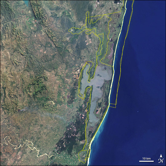
| İzah | Satellite image of w:Greater St. Lucia Wetland Park, South Africa. Borders of the various conservation areas in the park are outlined in yellow. |
| Tarix | |
| Mənbə | http://earthobservatory.nasa.gov/Newsroom/NewImages/images.php3?img_id=16722 |
| Müəllif | Jesse Allen, NASA Earth Observatory, using Landsat and GIS data obtained from the University of Maryland’s Global Land Cover Facility. |
| İcazə (Faylın təkrar istifadəsi) |
Public domain |
| Digər versiyalar | Larger, uncropped version available from source URL (sans borders). |
Lisenziya
| This file is in the public domain in the United States because it was solely created by NASA. NASA copyright policy states that "NASA material is not protected by copyright unless noted". (See Template:PD-USGov, NASA copyright policy page or JPL Image Use Policy.) | ||
 |
Warnings:
|
Faylın tarixçəsi
Faylın əvvəlki versiyasını görmək üçün gün/tarix bölməsindəki tarixlərə klikləyin.
| Tarix/Vaxt | Kiçik şəkil | Ölçülər | İstifadəçi | Şərh | |
|---|---|---|---|---|---|
| indiki | 16:10, 19 may 2006 | | 540 × 540 (102 KB) | Holly Cheng | {{Information | Description=Satellite image of w:Greater St. Lucia Wetland Park, South Africa. Borders of the various conservation areas in the park are outlined in yellow. | Source=http://earthobservatory.nasa.gov/Newsroom/NewImages/images.php3?img_i |
Fayl keçidləri
Aşağıdakı səhifə bu faylı istifadə edir:
Faylın qlobal istifadəsi
Bu fayl aşağıdakı vikilərdə istifadə olunur:
- af.wikipedia.org layihəsində istifadəsi
- ar.wikipedia.org layihəsində istifadəsi
- ast.wikipedia.org layihəsində istifadəsi
- avk.wikipedia.org layihəsində istifadəsi
- ca.wikipedia.org layihəsində istifadəsi
- cs.wikipedia.org layihəsində istifadəsi
- cv.wikipedia.org layihəsində istifadəsi
- cy.wikipedia.org layihəsində istifadəsi
- de.wikipedia.org layihəsində istifadəsi
- de.wikivoyage.org layihəsində istifadəsi
- en.wikipedia.org layihəsində istifadəsi
- eo.wikipedia.org layihəsində istifadəsi
- es.wikipedia.org layihəsində istifadəsi
- fi.wikipedia.org layihəsində istifadəsi
- fr.wikipedia.org layihəsində istifadəsi
- fr.wikivoyage.org layihəsində istifadəsi
- gl.wikipedia.org layihəsində istifadəsi
- he.wikipedia.org layihəsində istifadəsi
- hr.wikipedia.org layihəsində istifadəsi
- hu.wikipedia.org layihəsində istifadəsi
- hy.wikipedia.org layihəsində istifadəsi
- is.wikipedia.org layihəsində istifadəsi
- it.wikipedia.org layihəsində istifadəsi
- ja.wikipedia.org layihəsində istifadəsi
- ka.wikipedia.org layihəsində istifadəsi
- lv.wikipedia.org layihəsində istifadəsi
- mt.wikipedia.org layihəsində istifadəsi
- no.wikipedia.org layihəsində istifadəsi
- oc.wikipedia.org layihəsində istifadəsi
- pl.wikipedia.org layihəsində istifadəsi
- ru.wikipedia.org layihəsində istifadəsi
- sh.wikipedia.org layihəsində istifadəsi
- sk.wikipedia.org layihəsində istifadəsi
- sr.wikipedia.org layihəsində istifadəsi
- uk.wikipedia.org layihəsində istifadəsi
- vec.wikipedia.org layihəsində istifadəsi
- vi.wikipedia.org layihəsində istifadəsi
- www.wikidata.org layihəsində istifadəsi
Bu faylın qlobal istifadəsinə baxın.