Fayl:USS Bunker Hill hit by two Kamikazes.jpg
Sınaq göstərişi ölçüsü: 800 × 553 piksel. Digər ölçülər: 320 × 221 piksel | 640 × 443 piksel | 1.024 × 708 piksel | 1.280 × 885 piksel | 2.560 × 1.770 piksel | 2.962 × 2.048 piksel.
Faylın orijinalı (2.962 × 2.048 piksel, fayl həcmi: 1,25 MB, MIME növü: image/jpeg)
| Bu fayl "Vikimedia Commons"dadır və digər layihələrdə istifadə edilə bilər. |
 |
Faylın təsvir səhifəsinə get |
|
This image was selected as picture of the day on Wikimedia Commons for 21 January 2010. It was captioned as follows: Other languages:
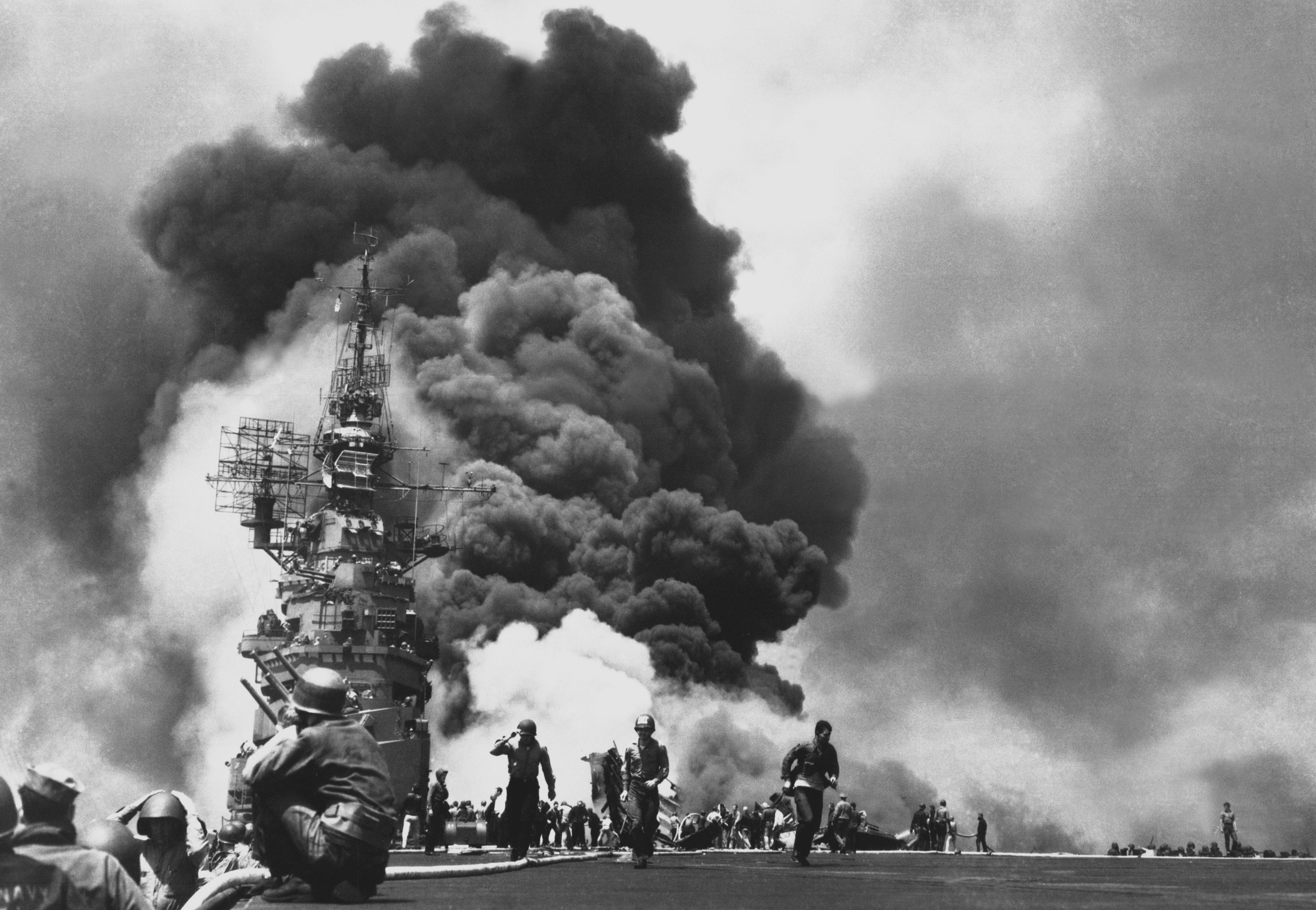
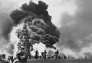
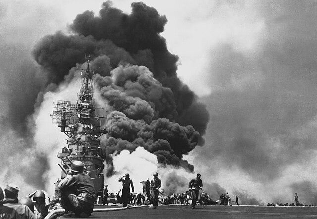
Čeština: Loď USS Bunker Hill (CV-17) po zásahu dvěma kamikaze v rozmezí třiceti sekund 11. května 1945 u Kjúšú; při útoku zemřelo 372 členů posádky, dalších 264 jich bylo zraněno Dansk: USS Bunker Hill rammes den 11. maj 1945 i løbet af 30 sekunder af to kamikazefly ud for Kyushu. Der omkom 372, mens 264 såredes. Deutsch: Die USS Bunker Hill wird am 11. Mai 1945 innerhalb von 30 Sekunden von zwei Kamikaze-Fliegern getroffen. 372 Personen sterben, 264 werden verwundet. Français : L'USS Bunker Hill vient d'être touché par deux kamikazes en l'espace de 30 secondes, le 11 mai 1945 au large de Kyushu. Bilan : 372 morts, 264 blessés. Italiano: 11 maggio 1945: la USS Bunker Hill, portaerei della Classe Essex, ha appena subito l'attacco di due kamikaze giapponesi al largo dell'isola di Kyūshū. Magyar: 1945. május 11-én fél percen belül két kamikazetámadás is elérte az amerikai USS Bunker Hill repülőgép-hordozót. A becsapódásoknak 264 sérültje és 372 halálos áldozata volt Nederlands: De bemanning van de USS Bunker Hill rent over het dek na de inslagen van twee Japanse kamikazevliegers 30 seconden achterelkaar op 11 mei 1945. Bij deze zelfmoordaanslagen tijdens de Slag om Okinawa kwamen 372 mensen om en raakten 264 gewond. Polski: 11 maja 1945 roku, płonie USS Bunker Hill trafiony przez dwóch kamikaze w odstępie trzydziestu sekund. 372 członków załogi zginęło, dalszych 264 odniosło rany. Română: Nava USS Bunker Hill lovită de doi kamikaze în decursul a 30 de secunde. 11 mai 1945, largul insulei Kyūshū. Svenska: Hangarfartyget USS Bunker Hill efter en attack från två kamikaze den 11 maj 1945. Беларуская (тарашкевіца): Авіяносец Банкер-Гіл пасьля двух удараў камікадзэ зь інтэрвалам у 30 сэкундаў. 11 траўня 1945 ля Кюсю. Македонски: Американскиот воен брод „Банкер Хил“, погоден од два камиказе-авиона во рок од 30 секунди на 11 мај 1945 недалеку од островот Кјушу. Загинати: 372, ранети: 264. Русский: Пожар на авианосце «Банкер-Хилл» после двух атак камикадзе с интервалом в 30 секунд. Окинава, 11 мая 1945 года Українська: Пошкоджений американський авіаносець USS Bunker Hill (CV-17) після двох атак камікадзе з інтервалом 30 секунд. Загинуло 372 членів екіпажу, поранено - 264. Острів Окінава, 11 травня 1945 р. বাংলা : ১৯৪৫ সালের ১১ মে দুইজন কামিকাজেস (জাপানি আত্মঘাতী হামলাকারী) ইউএসএস বাংকার হিলে বিস্ফোরণ ঘটিয়েছেন। ৩০ সেকেন্ডের এই বিস্ফোরণে নিহত হয়েছেন ৩৭২ জন, আর আহত হয়েছেন ২৬৪ জন। 中文: 1945年5月11日,美国航空母舰班克山号在30秒内被两位神风特别攻击队成员攻击,372人葬身,264人受伤。 中文(繁體): 1945年5月11日,美國航空母艦班克山號在30秒內被兩位神風特別攻擊隊成員攻擊,372人葬身,264人受傷。 עברית : USS Bunker Hill שנפגעה על ידי שני קימקזות תוך 30 שניות, ב-11 במאי 1945 ליד קיושו |
This image was selected as picture of the day on Vietnamese Wikipedia.
|
Xülasə
| İzah |
العربية: حاملة الطائرات الأمريكية بانكر هيل، بعد إصابتها من قبل انتحارِيَين، قبالة جزيرة كيوشو اليابانية، بتاريخ 11 مايو 1945، والنتيجة 372 قتيل و264 جريح.
Deutsch: Die USS Bunker Hill wird am 11. Mai 1945 innerhalb von 30 Sekunden von zwei Kamikaze-Fliegern getroffen. 372 Personen sterben, 264 werden verwundet.
English: "USS Bunker Hill (CV-17) hit by two Kamikazes in 30 seconds on 11 May 1945 off Kyushu. Dead-372. Wounded-264., 1943 - 1958", from Archival Research Catalog.
Français : L'USS Bunker Hill vient d'être touché par deux kamikazes en l'espace de 30 secondes, le 11 mai 1945 au large de Kyushu. Bilan : 372 morts, 264 blessés..
Italiano: 11 maggio 1945, al largo di Kyushu. La USS BUNKER HILL è colpita da due Kamikaze in 30 secondi. Morirono 372 persone, 264 feriti.
Türkçe: USS Bunker Hill uçak gemisinin 30 saniye içinde iki Japon kamikaze tarafından Kyūshū yakınında 11 Mayıs 1945'de vuruldu. (2.600 kişilik mürettebattan 346'sı öldü, 43'ü kayboldu ve 264'ü yaralandı.)
|
|||
| Tarix | ||||
| Mənbə |
[1] from Archival Research Catalog. |
|||
| Müəllif | U.S. Navy; The original uploader was Quercusrobur at ingilis Vikipediya.. | |||
| Digər versiyalar |
Official U.S. Navy photograph 80-G-323712 from U.S. Naval History and Heritage Command
|

![[1]](https://media.nara.gov/media/images/28/12/28-1118a.gif)
| Object location | | View this and other nearby images on: OpenStreetMap |
|---|
The geographical information in this file was retrospectively estimated.
The location may therefore be somewhat imprecise. Verifying and refining these coordinates is strongly encouraged. |
Lisenziya
This file is a work of a sailor or employee of the U.S. Navy, taken or made as part of that person's official duties. As a work of the U.S. federal government, it is in the public domain in the United States.
|
 | |
| This file has been identified as being free of known restrictions under copyright law, including all related and neighboring rights. | ||
Faylın tarixçəsi
Faylın əvvəlki versiyasını görmək üçün gün/tarix bölməsindəki tarixlərə klikləyin.
| Tarix/Vaxt | Kiçik şəkil | Ölçülər | İstifadəçi | Şərh | |
|---|---|---|---|---|---|
| indiki | 02:14, 26 iyun 2007 | | 2.962 × 2.048 (1,25 MB) | Dual Freq | full res version http://www.dodmedia.osd.mil/Assets/Still/1999/DoD/HD-SN-99-02639.JPEG |
| 16:00, 4 fevral 2005 |  | 1.378 × 1.113 (173 KB) | W.wolny |
Fayl keçidləri
Aşağıdakı səhifə bu faylı istifadə edir:
Faylın qlobal istifadəsi
Bu fayl aşağıdakı vikilərdə istifadə olunur:
- ar.wikipedia.org layihəsində istifadəsi
- بوابة:محتوى متميز
- ويكيبيديا:صور مختارة
- معركة أوكيناوا
- بوابة:الحرب العالمية الثانية/صورة مختارة/أرشيف
- ويكيبيديا:صور مختارة/تاريخ وأحداث
- ويكيبيديا:صور مختارة/تاريخ وأحداث/تاريخ عالمي
- بوابة:محتوى متميز/محتويات
- بوابة:محتوى متميز/محتويات/صور مختارة
- بوابة:محتوى متميز/الرئيسية
- مستخدم:ASammour/صور مختارة
- مستخدم:ASammour/صور مختارة في الفارسية والتركية
- ويكيبيديا:ترشيحات الصور المختارة/معركة أوكيناوا
- ويكيبيديا:صورة اليوم المختارة/يونيو 2023
- قالب:صورة اليوم المختارة/2023-06-03
- بوابة:الحرب العالمية الثانية/صورة مختارة/19
- ast.wikipedia.org layihəsində istifadəsi
- azb.wikipedia.org layihəsində istifadəsi
- ba.wikipedia.org layihəsində istifadəsi
- bcl.wikipedia.org layihəsində istifadəsi
- bg.wikipedia.org layihəsində istifadəsi
- bn.wikipedia.org layihəsində istifadəsi
- bs.wikipedia.org layihəsində istifadəsi
- ca.wikipedia.org layihəsində istifadəsi
- ceb.wikipedia.org layihəsində istifadəsi
- crh.wikipedia.org layihəsində istifadəsi
- cs.wikipedia.org layihəsində istifadəsi
- cv.wikipedia.org layihəsində istifadəsi
- cy.wikipedia.org layihəsində istifadəsi
- da.wikipedia.org layihəsində istifadəsi
- de.wikipedia.org layihəsində istifadəsi
- Schlacht um Okinawa
- Shimpū Tokkōtai
- Wikipedia:Exzellente Bilder
- USS Bunker Hill (CV-17)
- Wikipedia:Archiv/Bilderwettbewerb/Kategorie Bildbearbeitung
- Essex-Klasse (1942)
- Wikipedia:Exzellente Bilder/Geschichte
- Wikipedia:Kandidaten für exzellente Bilder/Archiv2007/13
- Datei:USS Bunker Hill hit by two Kamikazes.jpg
- Benutzer:Julien Then
- Benutzer:Lychee/CBDJ08
- el.wikipedia.org layihəsində istifadəsi
Bu faylın qlobal istifadəsinə baxın.