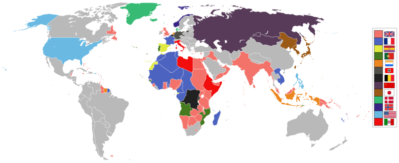
Fayl:World 1936 empires colonies territory.png

Faylın orijinalı (1.527 × 624 piksel, fayl həcmi: 44 KB, MIME növü: image/png)
| Bu fayl "Vikimedia Commons"dadır və digər layihələrdə istifadə edilə bilər. |
 |
Faylın təsvir səhifəsinə get |
1936 coolio stuff
Xülasə
العربية
English
മലയാളം
Deutsch
한국어
Українська
简体中文
繁體中文

|
This historical map image could be re-created using vector graphics as an SVG file. This has several advantages; see Commons:Media for cleanup for more information. If an SVG form of this image is available, please upload it and afterwards replace this template with
{{vector version available|new image name}}.
It is recommended to name the SVG file “World 1936 empires colonies territory.svg”—then the template Vector version available (or Vva) does not need the new image name parameter. |

|
Legal disclaimer This image contains a symbol prohibited by law in some nations, owing to it being a representation of communism, socialism, or a similar governmental structure; or of an associated political party/organization:
Imagery covered may include the hammer and sickleen, red star, emblems/insignias, flags or images of leaders. |

|
Legal disclaimer This image shows (or resembles) a symbol that was used by the National Socialist (NSDAP/Nazi) government of Germany or an organization closely associated to it, or another party which has been banned by the Federal Constitutional Court of Germany. The use of insignia of organizations that have been banned in Germany (like the Nazi swastika or the arrow cross) may also be illegal in Austria, Hungary, Poland, Czech Republic, France, Brazil, Israel, Ukraine, Russia and other countries, depending on context. In Germany, the applicable law is paragraph 86a of the criminal code (StGB), in Poland – Art. 256 of the criminal code (Dz.U. 1997 nr 88 poz. 553). |
See also
| Maps of world history | |
| BC | |
|
| |
| AD |
1 · 50 · 100 · 200 · 250 · 300 · 400 · 500 · 700 · 750 · 820 · 900 · 1200 · 1500 · 1556 · 1648 · 1700 · 1750 · 1815 · 1859 · 1871 · 1914 · 1989 · 2000 · |
|
Maps of colonization history | |
|
see also: Eastern Hemisphere only maps template (1300BC-1500AD) | |
| (this template: · view · discuss ) | |
.jpg)
._LOC_2001620596.jpg)
Lisenziya

|
Bu sənədi GNU Azad Sənədləşdirmə Lisenziyası, Versiya 1.2 və ya Azad Proqram Fondu tərəfindən nəşr olunan hər hansı sonrakı versiya şərtlərinə əsasən dəyişməz bölmələr, ön qapaq mətnləri və arxa qapaq mətnləri olmadan köçürmək, yayımlamaq və / və ya dəyişdirmək üçün icazə verilir; Lisenziyanın bir nüsxəsi GNU Azad Sənədləşdirmə Lisenziyası adlı hissəyə daxil edilmişdir. |
| Bu fayl Creative Commons Attribution-Share Alike 3.0 Unported lisenziyası altında yayımlanır. | ||
| ||
| This licensing tag was added to this file as part of the GFDL licensing update. |
Faylın tarixçəsi
Faylın əvvəlki versiyasını görmək üçün gün/tarix bölməsindəki tarixlərə klikləyin.
| Tarix/Vaxt | Kiçik şəkil | Ölçülər | İstifadəçi | Şərh | |
|---|---|---|---|---|---|
| indiki | 13:41, 6 may 2020 | 1.527 × 624 (44 KB) | The- | The Dominions should not be shaded in British Empire colour post-1931 Statute of Westmisnter. They had independent foreign policies and were no longer under British control in any way, shape or form. | |
| 12:34, 12 may 2019 | 1.527 × 624 (44 KB) | The- | If there are some problems with the accurate map, fix the accurate map, don't revert back to the old inaccurate map! | ||
| 07:34, 12 sentyabr 2018 |  | 1.458 × 627 (33 KB) | Oleksiy.golubov | Reverted to version as of 13:34, 29 July 2012 (UTC): no reason to indicate Turkey and China; colors of Belgium and the Netherlands were wrong. | |
| 19:51, 20 iyul 2018 | 1.527 × 624 (3,64 MB) | SuperSucker | oops forgot Germany had Nazi flag in 1936 | ||
| 19:39, 20 iyul 2018 | 1.527 × 624 (3,64 MB) | SuperSucker | fix - added Turkey (it existed as Turkey in 1936) and China; changed China's flag as they had it changed by 1930 | ||
| 14:47, 20 avqust 2016 | 1.527 × 624 (44 KB) | The- | Some fixes | ||
| 20:29, 17 aprel 2016 | 1.527 × 624 (44 KB) | The- | More accurate map | ||
| 13:34, 29 iyul 2012 |  | 1.458 × 627 (33 KB) | Faunas | Reverted to version as of 13:31, 29 July 2012 | |
| 13:33, 29 iyul 2012 |  | 1.458 × 627 (33 KB) | Faunas | In the previous version, São Tomé e Príncipe was indicated as a Spanish colony; I changed it to indicate it was a Portuguese colony (which it was). | |
| 13:31, 29 iyul 2012 |  | 1.458 × 627 (33 KB) | Faunas | In the previous version, São Tomé e Príncipe was indicated as a Spanish colony; I changed it to indicate it was a Portuguese colony (which it was). |
Fayl keçidləri
Aşağıdakı səhifə bu faylı istifadə edir:
Faylın qlobal istifadəsi
Bu fayl aşağıdakı vikilərdə istifadə olunur:
- af.wikipedia.org layihəsində istifadəsi
- am.wikipedia.org layihəsində istifadəsi
- ar.wikipedia.org layihəsində istifadəsi
- arz.wikipedia.org layihəsində istifadəsi
- bn.wikipedia.org layihəsində istifadəsi
- bs.wikipedia.org layihəsində istifadəsi
- de.wikipedia.org layihəsində istifadəsi
- en.wikipedia.org layihəsində istifadəsi
- fa.wikipedia.org layihəsində istifadəsi
- fr.wikipedia.org layihəsində istifadəsi
- ja.wikipedia.org layihəsində istifadəsi
- li.wikipedia.org layihəsində istifadəsi
- lv.wikipedia.org layihəsində istifadəsi
- mg.wikipedia.org layihəsində istifadəsi
- ms.wikipedia.org layihəsində istifadəsi
- nl.wikipedia.org layihəsində istifadəsi
- pt.wikipedia.org layihəsində istifadəsi
- sr.wikipedia.org layihəsində istifadəsi
- th.wikipedia.org layihəsində istifadəsi
- uk.wikipedia.org layihəsində istifadəsi
- www.wikidata.org layihəsində istifadəsi