Fayl:Dalriada.jpg
Daha yüksək versiyası yoxdur.
Dalriada.jpg (509 × 531 piksel, fayl həcmi: 34 KB, MIME növü: image/jpeg)
| Bu fayl "Vikimedia Commons"dadır və digər layihələrdə istifadə edilə bilər. |
 |
Faylın təsvir səhifəsinə get |
Xülasə
| İzah |
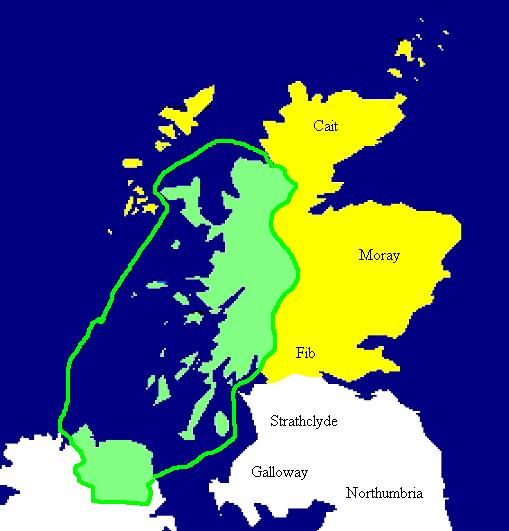
English: Extent of the Kingdom of Dál Riata (in green), c. AD 590. Yellow areas show occupation by the Picts.
Español: Mapa de Dalriada hacia el año 590. Las regiones pictas están marcadas en amarillo. |
| Mənbə | Copied from en:Image:Dalriada.jpg. |
| Müəllif | en:User:Briangotts |


|
This historical map image could be re-created using vector graphics as an SVG file. This has several advantages; see Commons:Media for cleanup for more information. If an SVG form of this image is available, please upload it and afterwards replace this template with
{{vector version available|new image name}}.
It is recommended to name the SVG file “Dalriada.svg”—then the template Vector version available (or Vva) does not need the new image name parameter. |
Lisenziya
| This work has been released into the public domain by its author, Briangotts. This applies worldwide. In some countries this may not be legally possible; if so: |
Faylın tarixçəsi
Faylın əvvəlki versiyasını görmək üçün gün/tarix bölməsindəki tarixlərə klikləyin.
| Tarix/Vaxt | Kiçik şəkil | Ölçülər | İstifadəçi | Şərh | |
|---|---|---|---|---|---|
| indiki | 15:49, 27 sentyabr 2005 | | 509 × 531 (34 KB) | R | Copied from en:Image:Dalriada.jpg. Author: en:User:Briangotts. Extent of the Kingdom of Dalriada (in green), c.590 CE. Yellow areas show occupation by the Picts. {{PD}} |
Fayl keçidləri
Aşağıdakı səhifə bu faylı istifadə edir:
Faylın qlobal istifadəsi
Bu fayl aşağıdakı vikilərdə istifadə olunur:
- ar.wikipedia.org layihəsində istifadəsi
- ast.wikipedia.org layihəsində istifadəsi
- bn.wikipedia.org layihəsində istifadəsi
- br.wikipedia.org layihəsində istifadəsi
- ca.wikipedia.org layihəsində istifadəsi
- cs.wikipedia.org layihəsində istifadəsi
- cy.wikipedia.org layihəsində istifadəsi
- da.wikipedia.org layihəsində istifadəsi
- de.wikipedia.org layihəsində istifadəsi
- en.wikipedia.org layihəsində istifadəsi
- es.wikipedia.org layihəsində istifadəsi
- eu.wikipedia.org layihəsində istifadəsi
- fi.wikipedia.org layihəsində istifadəsi
- fr.wikipedia.org layihəsində istifadəsi
- gd.wikipedia.org layihəsində istifadəsi
- gl.wikipedia.org layihəsində istifadəsi
- it.wikipedia.org layihəsində istifadəsi
- nds.wikipedia.org layihəsində istifadəsi
- nl.wikipedia.org layihəsində istifadəsi
- no.wikipedia.org layihəsində istifadəsi
- pl.wikipedia.org layihəsində istifadəsi
- pt.wikipedia.org layihəsində istifadəsi
- ro.wikipedia.org layihəsində istifadəsi
- ru.wikipedia.org layihəsində istifadəsi
- sv.wikipedia.org layihəsində istifadəsi
- uk.wikipedia.org layihəsində istifadəsi
Bu faylın qlobal istifadəsinə baxın.